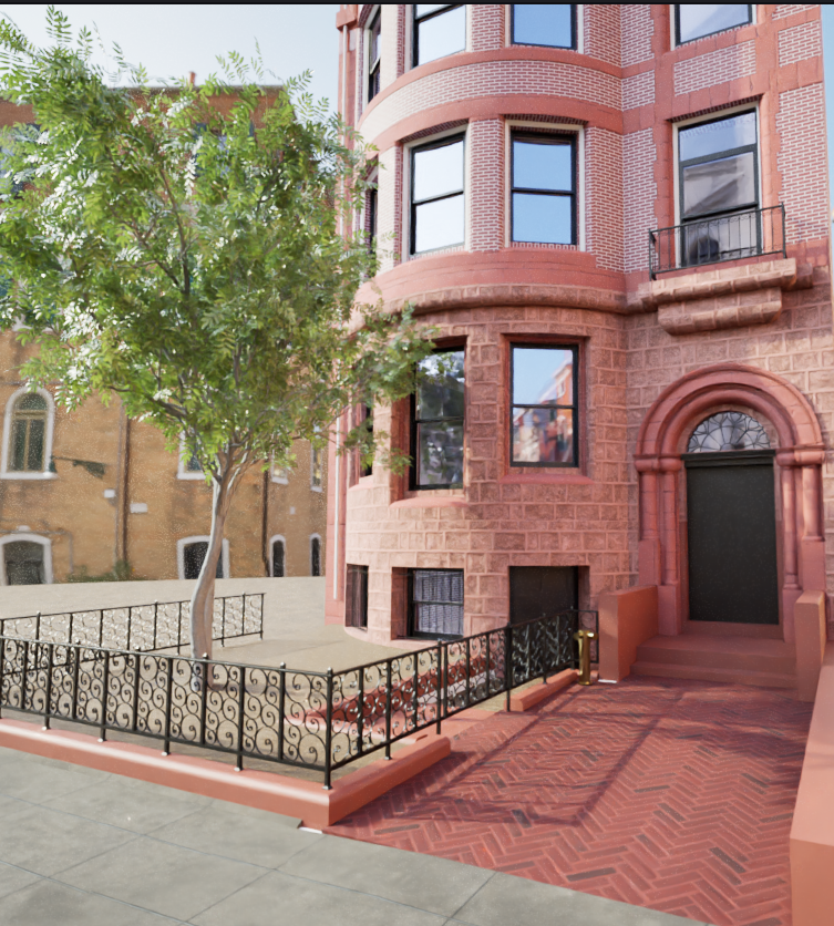
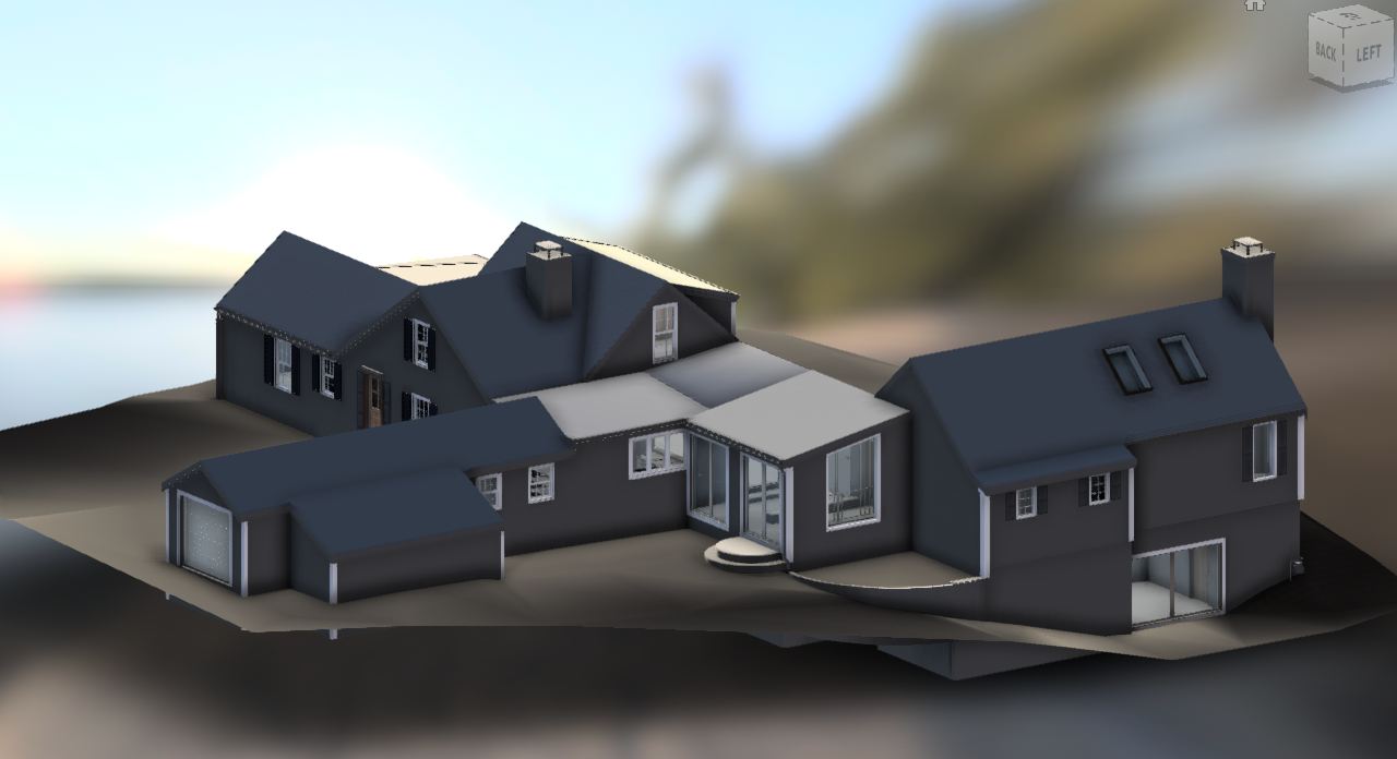
Tucked along one of Beacon Hill’s historic mews — narrow service lanes once home to stables and carriage houses — this property reflects a quieter layer of Boston’s architectural history. Many of these former service buildings have evolved into distinctive residences, known for their compact footprints, structural quirks, and unexpected spatial character and between World War I and World War II it housed the Massachusetts office of the Women’s International League for Peace and Freedom
The original scope for this project called for measured floor plans and exterior elevations. Once on site, it was clear the building deserved a more complete digital baseline. We documented the property in full, producing accurate drawings alongside a detailed Revit existing-conditions model. This allowed the design team to work from reliable geometry while quickly generating additional views, sections, and perspectives as the project evolved.
To help bring the space to life visually, we also developed Twinmotion renderings and created an HDRI environment from 360 capture. This workflow allows the model to sit within a realistic Beacon Hill streetscape, with natural lighting and reflections that match the surrounding environment.
Project Deliverables
Measured floor plans
Exterior elevations
Revit existing-conditions model
Exported drawing views and perspectives
Twinmotion visualizations
HDRI environment built from 360 site capture
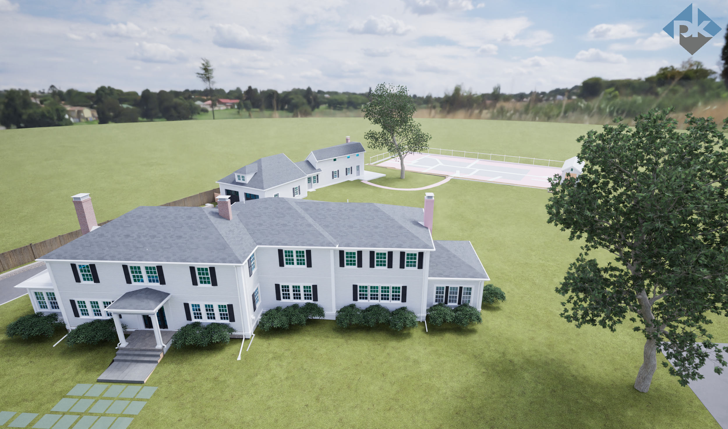
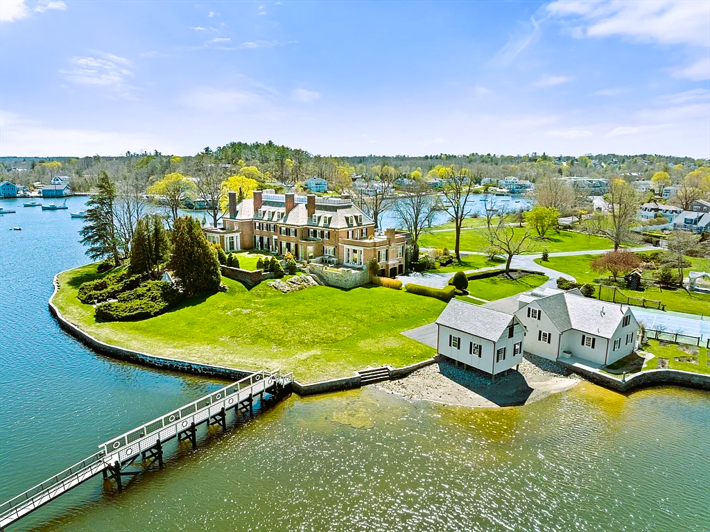
This coastal South Shore property in Hingham, Massachusetts blends classic New England architecture with a thoughtfully designed landscape that includes a main residence, carriage house, tennis court, and supporting outbuildings.
Pointknown was brought in to create a complete set of existing-conditions documentation and 3D digital models to support ongoing design and planning efforts. Let’s just say — it’s a stunning property… and next time we’re taking the ferry.
Project Overview
Our team performed a full reality capture and modeling scope across the entire property, delivering accurate, architect-ready digital assets while preserving the character and layout of the existing structures and grounds.
Scope of Work Included:
Main House – Interior & Exterior Capture
Carriage House Documentation
Full Site & Grounds Modeling
Tennis Court & Accessory Shed
Landscape Context & Circulation Areas
To ensure both design precision and spatial understanding, we combined terrestrial capture, drone data, and immersive media to create a complete digital record of the property as it exists today.
Technology & Capture Methods
We utilized a combination of advanced field capture tools to document the structures and site with a high level of detail and spatial accuracy:
Laser Scanning & Reality Capture for precise building geometry
Drone Aerial Imaging to capture roof conditions, site layout, and landscape relationships
360° Video Walkthroughs to provide contextual reference for designers and stakeholders
This layered approach ensures the design team can understand not only dimensions — but also how spaces feel, connect, and flow.
3D Modeling & Visualization
All captured data was translated into a detailed Revit model built to align with the client’s architectural template standards, allowing for seamless integration into their ongoing design workflow.
Deliverables included:
Revit models of the Main House and Carriage House
Modeled site features and recreational structures
Coordinated building and landscape context
To further enhance spatial understanding, we produced existing-condition renderings in Twinmotion, allowing stakeholders to visually explore the property in a realistic 3D environment before design changes begin.
Why It Matters
Projects like this highlight the importance of accurate existing-condition documentation when working with large properties, multiple structures, and landscape features. By delivering a coordinated digital foundation, we help design teams move forward with confidence — minimizing guesswork, return site visits, and surprises in the field.
And while the drive to Hingham can test your patience, capturing places like this is always worth the trip.
Planning a renovation, addition, or site transformation?
We measure once so you can design right.
📩 projects@pointknown.com
🌐 pointknown.com
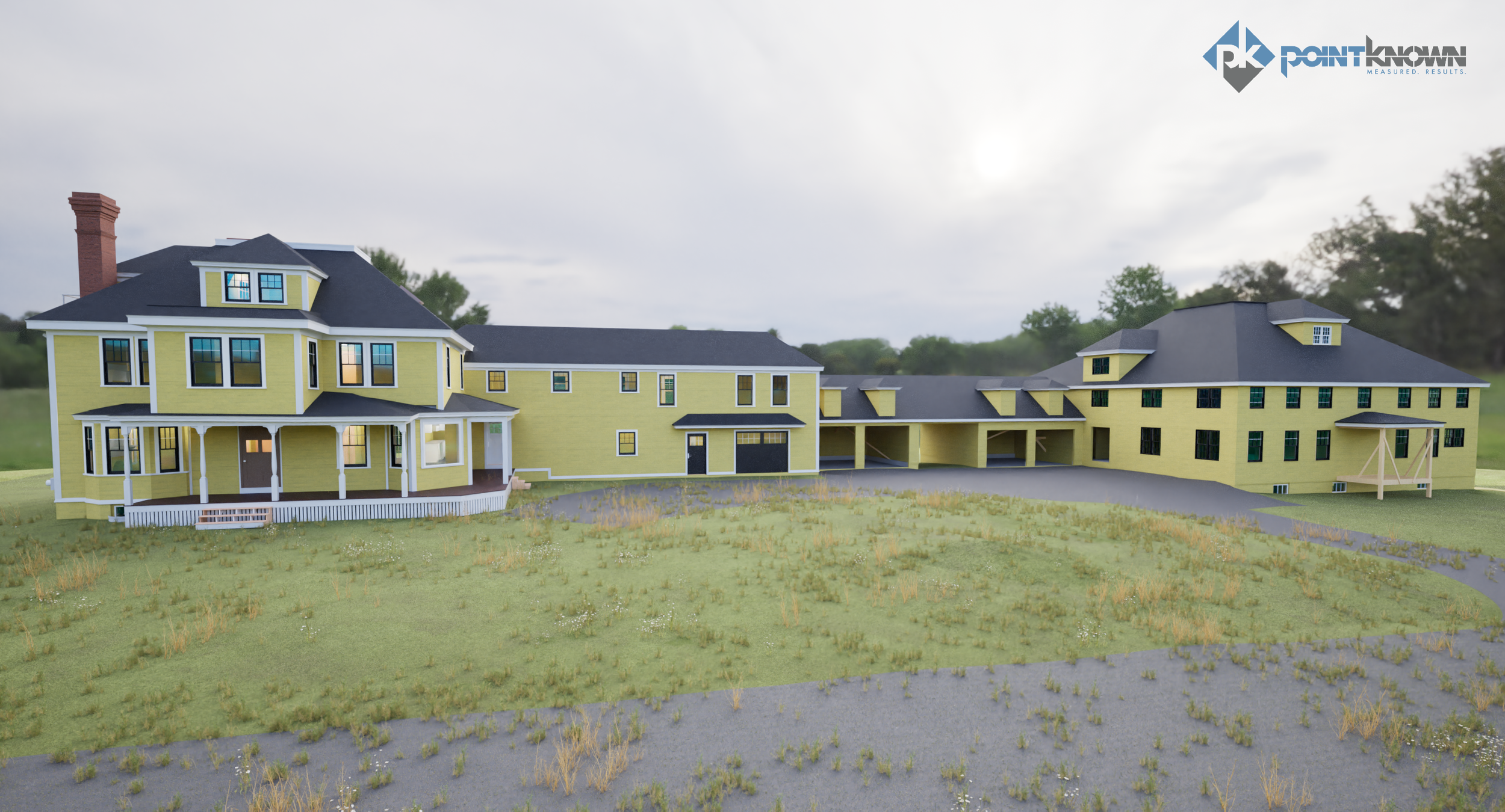
This historic property along Fitchburg Turnpike in Concord, Massachusetts is entering a new chapter—transforming from a partially completed structure into a future wellness retreat.
Pointknown was brought in to document the entire site using laser scanning and drone photogrammetry, then translate that data into a clean, design-ready package: CAD drawings, a full Revit model, and Twinmotion visuals to help the project team plan the next phase with clarity and confidence.
Concord is a place where history and reinvention naturally intersect. From its early American roots to the industrial and rail growth that shaped West Concord in the 1800s, the town has always balanced preservation with progress. This project continues that tradition—capturing what exists today to support what comes next.
Project Snapshot
Location: Concord, MA (Fitchburg Turnpike corridor)
Property Type: Historic residential compound with multiple structures
Project Goal: Existing-conditions documentation to support adaptive reuse into a wellness retreat
Pointknown Services: Site + building capture, CAD exports, Revit modeling, Twinmotion visuals
Why This Capture Was Important
Properties in transition often contain a mix of original construction, unfinished work, and undocumented changes. That uncertainty can slow design and introduce risk.
Reality capture provides one reliable source of truth:
Accurate geometry across all structures
Fewer assumptions during design
Reduced field revisits
Clearer coordination between architects, engineers, and owners
By capturing everything once, the team can move forward with confidence.
What We Captured
Mobile Laser Scanning
We documented interior and exterior building geometry to produce accurate existing conditions throughout rooms, circulation paths, structural elements, and roof transitions—especially valuable in older buildings where irregularities are common.
Drone Aerial Capture
Aerial flights captured roof forms, elevations, and full site context, supporting early planning and exterior coordination.
Deliverables
Existing Conditions CAD Drawings
Floor plans
Exterior elevations
Building sections as required
Key overhead and structural conditions
Site context exports for planning and consultant use
Revit Model
A fully navigable and measurable model that allows the design team to:
Generate additional sections and views on demand
Coordinate new design work with existing geometry
Export to multiple formats for consultants and permitting
The Outcome
The project team now has a unified digital foundation to support the building’s transformation into a wellness retreat:
Faster design iteration
Fewer unknowns
Reduced need for repeat site visits
Improved communication across the team
For renovation and adaptive reuse projects—especially historic properties—clear existing-conditions data is the starting point for smart design decisions.
Planning a renovation or adaptive reuse project?
We capture once and deliver models and drawings your team can rely on.
Marston Mills, Cape Cod MA
Coastal Estate | Existing Conditions & Site Modeling
Project Overview
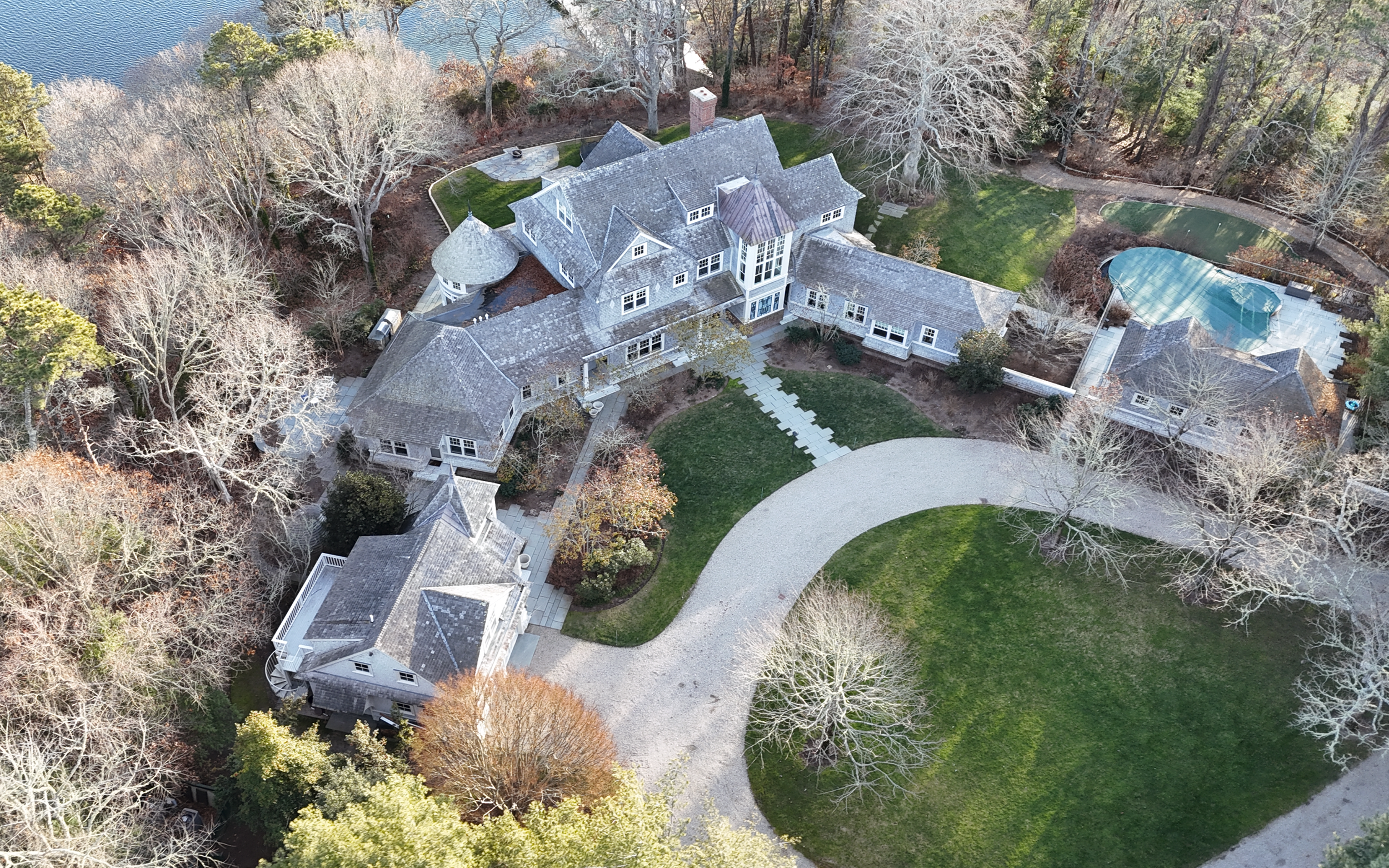
This project involved comprehensive existing‑conditions documentation of a multi‑acre coastal estate in Marston Mills, Cape Cod, Massachusetts. The scope extended well beyond a single structure—capturing the entire site and multiple buildings with a level of detail that allowed the design team to move immediately into planning, analysis, and future design work.
Set directly along the coast, the property includes a main residence, carriage house, pool house, tennis court, and landscaped grounds, all of which were captured, modeled, and coordinated into a unified digital dataset.
Scope of Work
Site & Topography
Mobile and aerial reality capture of the full multi‑acre property
Detailed terrain modeling and terraforming of the entire site
Creation of a site plan with 1‑foot contour intervals, exported to AutoCAD for direct use by architects, landscape architects, and engineers
Modeling of exterior site features including paths, hardscape, and play structures / swing sets
Buildings & Structures
Laser scanning and modeling of:
Main House
Carriage House
Pool House
Full exterior and interior existing‑conditions documentation
Architectural Detail
High‑fidelity modeling of the main residence’s dramatic three‑story vaulted space, including:
Floor‑to‑ceiling window systems
Integrated shelving
Second‑floor atrium walkway
Cast‑iron structural supports
This level of detail allows the model to function not only as a record of existing conditions, but as a design‑ready foundation for future architectural work.
Deliverables
AutoCAD
Complete site plan with 1’ contour intervals
Architectural plans, sections, and elevations exported directly from the model
SketchUp
Entire property and building set exported for flexible use by designers, builders, and consultants
3D Views & Diagrams
3D floor plan views
Exterior and interior elevations
Sectional perspectives illustrating complex spatial relationships
Twinmotion Visualizations
Contextual renderings produced to clearly communicate scale, terrain, and architectural character
Used primarily for visual storytelling and documentation on our website
Why This Matters
By capturing the entire estate—from coastal terrain to architectural detail—the project team received a coordinated, accurate digital baseline. This approach reduces uncertainty, accelerates design workflows, and allows all stakeholders to work from the same trusted source of information.
At Pointknown, we focus on delivering measure‑once, design‑right documentation—especially on complex properties where site, structure, and architecture are deeply interconnected.
Tools & Technology
Mobile LiDAR laser scanning
Drone photogrammetry
AutoCAD
SketchUp
Revit (model coordination and export source)
Twinmotion (visualization)
Project location shown as Marston Mills, Cape Cod MA. Specific address withheld for client privacy.
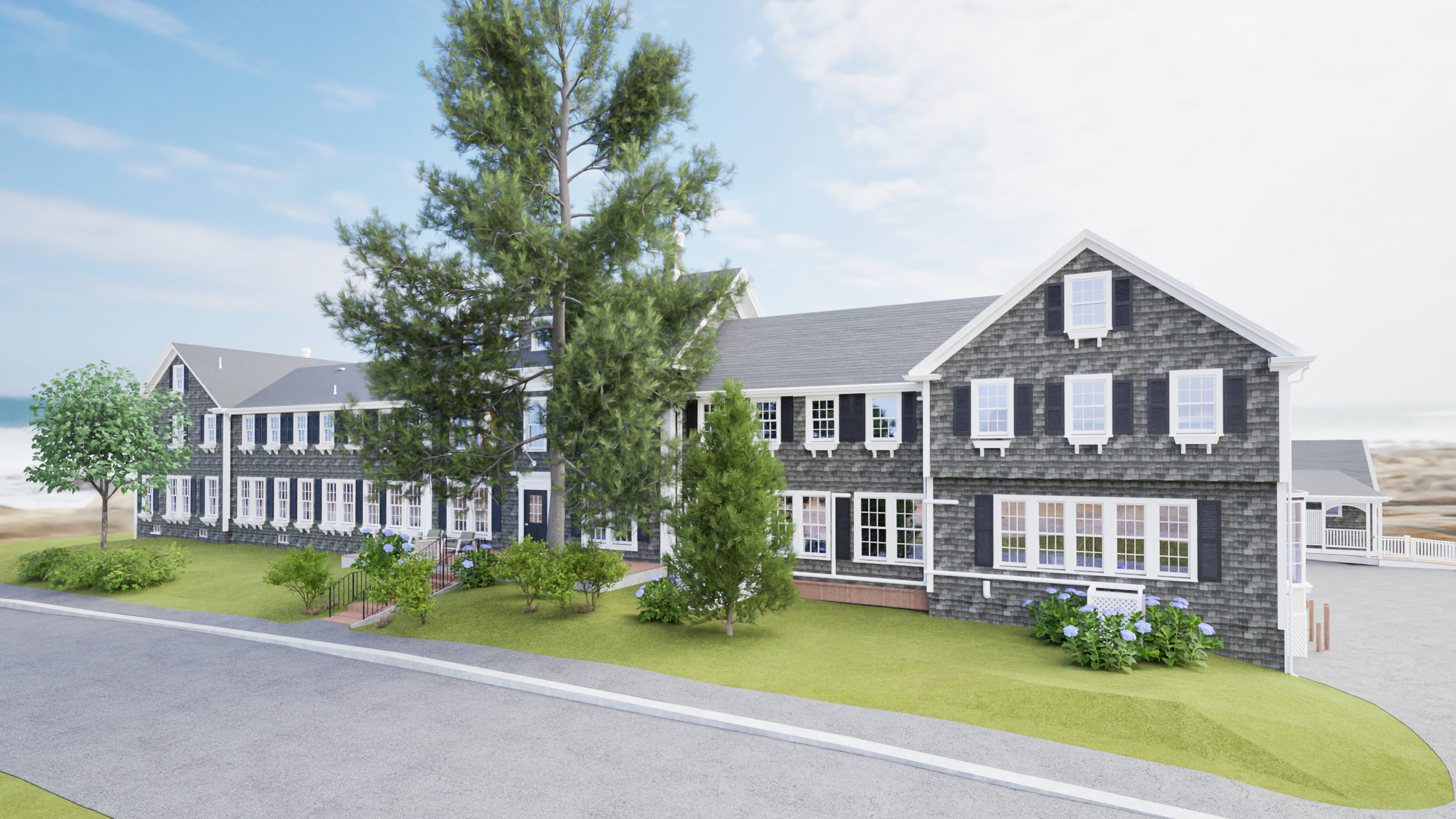
Queen Anne Inn — Chatham, Massachusetts
Pointknown was brought in to document existing conditions at the historic Queen Anne Inn in Chatham, MA—capturing precise, shareable 3D data that supports renovation planning, design coordination, and long-term facility decisions.
Working in an active hospitality environment requires speed, accuracy, and minimal disruption. Our reality-capture workflow enabled us to quickly collect comprehensive interior/exterior geometry and deliver clean, actionable outputs for architects, owners, and project teams.
A little local context
Chatham is one of Cape Cod’s most storied coastal towns—shaped by maritime trade, fishing, and generations of seasonal visitors. The Queen Anne Inn itself traces back to the mid-1800s, originally built by the Taylor family, early promoters of Chatham as a vacation destination, and later operated by the Swan family for decades. Cape Cod Chronicle
What we captured
Key interior spaces and architectural features (walls, stairs, millwork, openings)
Exterior massing and site context for design coordination
Critical dimensions needed for renovation planning and documentation
Tools + approach
Mobile LiDAR/SLAM scanning for efficient interior capture
Targeted tripod/spot scanning where tighter detail or control was needed (as applicable)
Registration + QA to support dependable downstream modeling and drawing production
Deliverables (typical for this type of project)
Registered point cloud (for design + measurement)
Existing-conditions 2D plans and/or CAD exports (as needed)
Existing-conditions 3D model option (Revit or other formats) for teams that want a “future-built” base
Why it matters
For complex or historic properties, accurate existing documentation reduces surprises—helping teams coordinate faster, minimize change orders, and confidently plan upgrades while respecting the building’s character.
Need documentation for a historic property or Cape Cod renovation?
Pointknown supports architects, owners, and contractors with fast, premium reality capture—built for real-world project schedules.
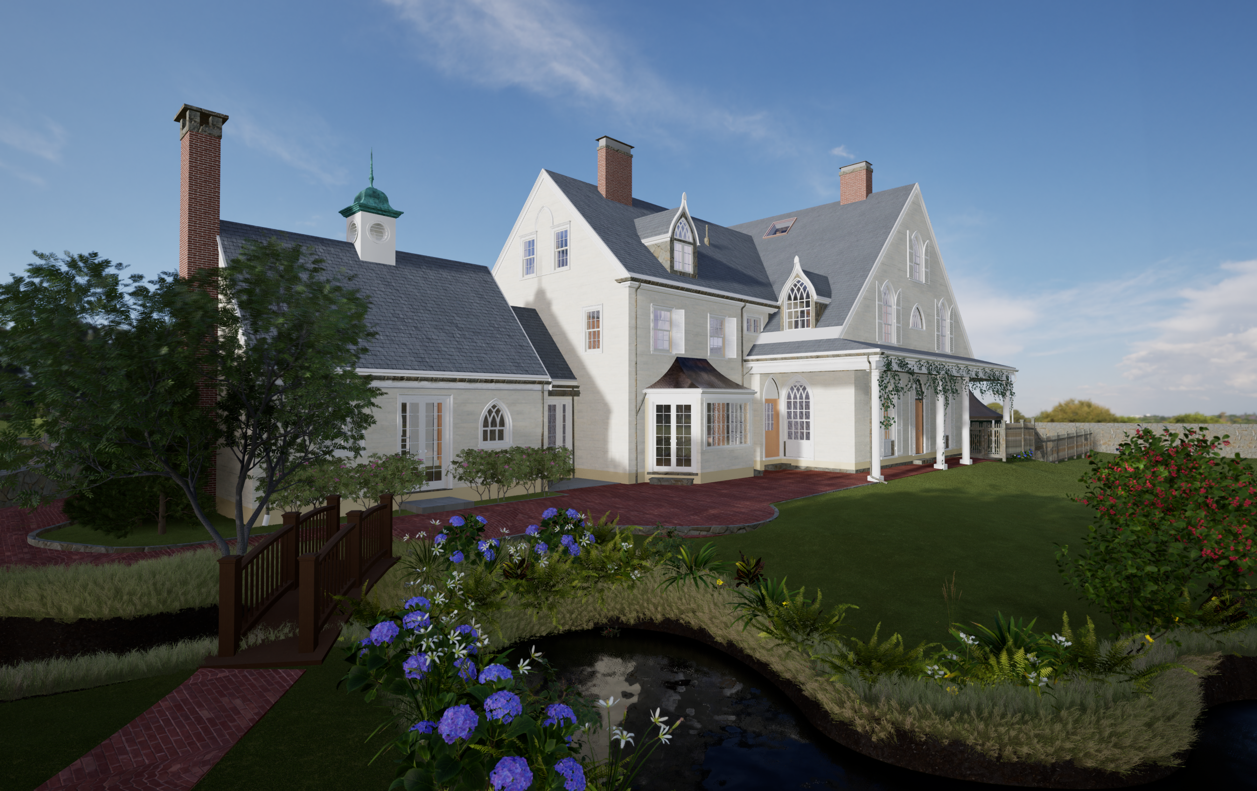
For this residential project in Brookline, Pointknown was engaged to document a Gothic Revival–style property where architecture and landscape are deeply interconnected. The scope extended well beyond the primary residence to include a detached carriage house, dramatic elevation changes, exposed ledge, and a natural stream running through the site.
The Gothic Revival style—defined by its vertical proportions, steep rooflines, and expressive detailing—demands an exceptional level of accuracy when preparing for renovation or restoration. Equally critical was capturing the surrounding terrain, where topography and natural features directly influence design feasibility, drainage, and constructability.
Using a combination of mobile laser scanning, terrestrial LiDAR, drone photogrammetry, and ground-based imagery, we created a unified digital representation of the entire property. The result is a highly accurate existing-conditions model that allows project teams to understand the site as a single, connected system—architecture, land, and natural features working together.
Scope of Work
Reality Capture
LiDAR scanning of the Gothic Revival main residence and carriage house
Drone capture of roof geometry, elevation change, and site context
Ground-based scanning of terrain, ledge outcroppings, and stream corridor
3D Modeling & Documentation
Detailed existing-conditions model of all structures
Modeled site topography reflecting true grade and slope
Ledge and natural site features modeled for design coordination
Stream alignment and surrounding landscape captured for planning and review
Deliverables
Coordinated 3D model suitable for architectural, structural, and civil workflows
Accurate base model supporting restoration, renovation, and permitting efforts
Why This Matters
Historic properties set within complex landscapes require more than traditional building documentation. By capturing both the Gothic Revival architecture and the natural terrain as one integrated dataset, design teams gain the clarity needed to:
Respect and preserve historic character
Anticipate grading, drainage, and foundation challenges
Reduce risk during permitting and construction
Make informed decisions grounded in real-world conditions
This approach is especially valuable for hillside and environmentally sensitive sites, where assumptions can quickly become costly.
Location
Brookline, Massachusetts
Located in the wooded landscape of Eastham, Massachusetts, this mid century modern residence reflects a clear architectural language defined by structure, light, and a strong connection to its surroundings. Pointknown was engaged to capture and translate the property into a precise, future-ready digital model.
Using our standard reality-capture toolset — including mobile laser scanning, terrestrial LiDAR, and photogrammetry — we documented the full interior and exterior of the home, with particular attention to structural expression, roof geometry, glazing, and spatial relationships characteristic of mid century modern design.
The captured data was processed into a high-fidelity existing-conditions Revit model, allowing the project team to work within a flexible BIM environment that supports design, documentation, and long-term reuse. From the Revit model, we generated CAD plans, sections, and elevations, enabling seamless integration into a wide range of architectural workflows.
The model was also brought into Twinmotion to produce a series of visualizations used to study massing, materials, and the home’s relationship to the surrounding landscape.
This project highlights Pointknown’s approach: accurate field capture, intelligent modeling, and deliverables designed to remain valuable well beyond a single phase of work.
Services Provided
Mobile & Terrestrial Laser Scanning (LiDAR)
Existing-Conditions Revit Modeling
CAD Plans, Sections & Elevations
Roof & Exterior Geometry Documentation
Architectural Visualizations (Twinmotion)
Multi-format, future-ready deliverables
Project Info
Location: Eastham, Massachusetts
Project Type: Residential – Mid Century Modern
Scope: Full building documentation & visualization
Project Overview
We delivered a complete existing-conditions package in Weston, combining high-fidelity reality capture with coordinated BIM. Our team produced extensive CAD output, a full set of interior elevations, and both Revit and SketchUp models—built from trusted site data and quality-controlled to support downstream design, coordination, and construction.
Highlights
Unified point-cloud + photo dataset as a single source of truth
Measured accuracy for confident design decisions
Clear handoff: Revit model, CAD sheets, and interior elevations aligned
Scope & Deliverables
Reality Capture & Data Integration
Terrestrial laser scanning (LiDAR) and high-res field photography
Targeting, registration, and QA checks
Unified point cloud aligned to project coordinates
CAD & Drawings
Plans, sections, and detailed interior elevations
Layered CAD with consistent lineweights and naming standards
BIM & 3D Models
Revit model with families, parameters, and sheets for coordination
SketchUp model for rapid visualization and stakeholder reviews
Handoff Package
Revit (RVT), CAD (DWG), point cloud (RCP/E57, per agreement), PDFs, and model exports
Methods & Workflow
Capture → Validate → Model → Document
On-Site Data Collection
Laser scanning across interiors and key exterior faces; targeted control; overlap for coverage.
Registration & QA
Cloud alignment, drift checks, coverage review, and spot-measure validation.
Modeling & Drafting
Revit modeling of architecture and key systems; interior elevation set; CAD sheets by discipline.
Coordination & Issue Resolution
Model checks, naming standards, layer/family consistency, and review comments resolved.
Final Delivery
Clean, organized files for design teams, builders, and owners.
Tools We Used
Capture: LiDAR laser scanning, photogrammetry, 360° context imagery
Authoring: Autodesk Revit, AutoCAD, SketchUp
QA/QC: Registration reports, deviation checks, standardized templates
Image / Gallery Captions (use as alt text + captions)
Point cloud overview — main level alignment
Revit model cutaway — stair and circulation core
Interior elevation set — kitchen + built-ins
CAD section through primary volume
SketchUp massing — early visualization snapshot
QA registration summary — target and overlap coverage
Results
With a coordinated BIM and drawing set in hand, the project team moves forward with fewer assumptions—accelerating design options, simplifying coordination, and reducing rework during construction.
Looking for similar documentation?
We tailor scope to your risk, schedule, and budget—whether you need a light-touch model or full interior elevations and CAD.
Project Overview
At the scenic Shipyard Lane residence in Mattapoisett, Massachusetts, our team at Pointknown captured full existing conditions of both the home and its surrounding hardscape and waterfront context. Situated in a dynamic coastal setting, the project required precision in capturing complex geometry, exterior façades, site topography, and interior volumes—all seamlessly integrated into one deliverable.
Scope of Work
Terrestrial SLAM/mobile LiDAR scanning of interior and exterior spaces, including high-coverage scans of structural and façade elements.
Drone photogrammetry and aerial imagery to capture roof geometry, waterfront context and surrounding site hardscape.
360° panoramic video and high-resolution photography to supplement spatial context, preserve finishes, and support stakeholder communication.
Registration of all scan clouds into a unified point-cloud.
Conversion into design-ready outputs: Revit (.RVT) model, AutoCAD (DWG/PDF) plans & elevations, and point-cloud exports (E57/RCP) for future use by architects and contractors.
Deliverables
Revit model of the residence including major structural/architectural elements, window/door openings, and surrounding hardscape.
AutoCAD sheet set: floor plans, exterior elevations, site plan and sections.
360° walk-through visuals for design teams and owner reference.
Technology & Workflow
Utilizing the latest capture and processing technologies, our workflow combined mobile SLAM scanning for rapid interior capture, tripod-mounted LiDAR for high-density facade mapping, and drone grid flights for site and roof context. Data aggregation occurred in Autodesk ReCap and CloudCompare for registration and QA, followed by modelling in Autodesk Revit. This approach provided a true digital twin that design teams can trust. Pointknown+2Pointknown+2
Results & Impact
The Mattapoisett waterfront residence now sits on a fully documented digital baseline: the architecture, site and hardscape are mapped with millimetre-level accuracy. Architects and designers can begin their work knowing they’ve got verified geometry, avoiding costly re-visits or measurement assumptions. The owner now holds a rich model and drawing set to support renovation, addition or long-term facility planning.
Why This Project Matters
Waterfront homes pose unique challenges: non-orthogonal facades, complex terrain, roof overhangs, and site features like decks or seawalls. At Shipyard Lane, we captured all of these with our hybrid capture strategy—ensuring the data is not only accurate but also usable for downstream design and construction. Clients love that we provide “digital confidence” at the start of their project.
Margin Street – Cohasset, MA
Existing Conditions Documentation for a Historic Coastal Home
Pointknown was engaged to capture the existing conditions of a historic home on Margin Street in Cohasset, Massachusetts, a picturesque coastal town with a rich maritime history dating back to the 17th century. Nestled along the Atlantic shoreline, this property combines coastal charm with architectural character—making precise documentation essential for any renovation or preservation effort.
Our team utilized a full suite of tools to provide comprehensive building documentation:
Mobile Laser Scanning for fast and accurate measurement of interior and exterior spaces
360° Photography and Video to create a complete visual reference for stakeholders
High-resolution DSLR Photography to capture architectural and material details
Drone Imaging to document complex roof geometries and site context from above
From this data, we produced:
A Revit model of the structure and site
2D CAD drawings including plans, elevations, and sections
A site plan reflecting topography, hardscapes, and surrounding features
This model now serves as a reliable base for architects, designers, and contractors planning updates or additions to the property. By combining laser-precise measurements with rich visual context, we deliver clarity and confidence to our clients at every stage of their project.
LOCATION:
Radcliffe Quadrangle / Harvard University, Cambridge MA
Headline
Radcliffe Yard, Harvard University – Comprehensive 3D Laser Scanning & BIM Modeling
Project Overview
At the heart of Harvard University’s historic Radcliffe Yard campus in Cambridge, Massachusetts, our team at Pointknown was commissioned by the architectural firm ARC to deliver full-existing-conditions documentation across several key buildings: Cabot House, Holmes Hall, Bertram Hall, and Eliot Hall.
Challenge
The client required high-fidelity Revit/BIM models to support upcoming renovation and adaptive reuse work on these early 20th-century structures. Traditional field-measurement methods posed risks of inaccuracy, extended timelines and cost-drift amid active campus operations.
Solution
We executed a hybrid reality-capture workflow:
Terrestrial laser scanning with Faro Focus + handheld/SLAM units
Mobile LiDAR mapping and targeted drone photogrammetry to capture rooftops and facades
Registration of point-clouds, integration of existing CAD drawings, and model build-out in Revit
Deliverables
Full‐scale Revit models for Cabot House (exterior + select interiors) and supplemental interior/exterior models for Holmes Hall, Bertram Hall, and Eliot Hall
Linked point-cloud and photo dataset for verification and QA
2D CAD exports and interior elevation sheets for downstream use
Results & Benefits
Delivered a single source of truth: unified 3D model aligned to campus coordinate system, reducing need for re-measurements or repeat site visits
Enabled design and construction teams to move rapidly into schematic and detailed design phases, confident in as-built accuracy
Enhanced long-term facility documentation for Harvard’s historic portfolio, supporting maintenance, renovation, and digital-asset management
Technology Spotlight
Tools used: Faro Focus, GeoSLAM mobile scanners, tripod & handheld laser range-finders, DJI Mavic / Mini drones, Autodesk ReCap, Autodesk Revit, CloudCompare, Pix4D, GoPro MAX & GoPro Player
About Pointknown
Pointknown specializes in reality capture, laser scanning, mobile LiDAR and drone‐based mapping for existing building documentation, historic campuses and complex infrastructure. From interior point clouds to fully populated BIM models, we deliver the digital backbone your architects, engineers and contractors need to start strong.
Ready to get started?
If you’re embarking on a renovation or adaptive-reuse project—especially on a challenging site or historic structure—get in touch with us to discuss how accurate data can transform your design and construction outcomes.
Overview
Pointknown documented multiple buildings on Yale’s New Haven campus, including Sheffield-Sterling-Strathcona (SSS) Hall and Ray Tompkins House. Our team captured accurate existing conditions and delivered coordinated Revit as-built models to support planning, design, and facilities workflows.
Highlights
Historic, complex architecture captured with high fidelity including Sheffield-Sterling-Strathcona Hall (SSS) Hall’s neo-Gothic details.
Coordinated deliverables ready for architects, engineers, and campus facilities teams
Reduced site revisits with a single, verified digital baseline
Scope of Work
Campus assets: SSS Hall, Ray Tompkins House, and an additional building on St. Ronan Street (context capture). Pointknown
Interior & exterior reality capture for geometry, major systems, and adjacencies
Model coordination with campus standards and downstream consultant needs
Deliverables
Revit as-built models (by area, discipline, and level)
Exported CAD backgrounds and view sets as required
Curated point clouds for future reference & QA
Approach & Technology
Terrestrial LiDAR and complementary mobile SLAM for speed + coverage
Photogrammetry for texture and context
Structured QA/QC to validate dimensions, levels, and references before handoff
Outcomes
Faster planning & design starts with fewer field unknowns
Reduced change risk through verified dimensions and references
Reusable campus dataset for future projects
Location
New Haven, Connecticut (Yale University campus)
Call to Action
Planning a campus renovation or historic upgrade? Let’s talk about a verified digital baseline for design and operations.
Pointknown documented Daniels Hall at Worcester Academy using a blend of mobile LiDAR laser scanning and drone capture—bringing the entire facility into a clean, future-ready Revit existing-conditions model. From the indoor track, pool, and gymnasium to the exposed structure and rooftop solar panels, our goal was simple: deliver accurate building truth that architects can immediately design from.
What We Captured
Indoor athletics spaces: indoor track, pool, gymnasium
Full building geometry: walls, openings, stairs, mezzanines, and architectural features
Exposed systems & structure: HVAC runs, trusses, supports, and overhead conditions
Roof + solar panels: drone capture to document rooftop layout and key features
What We Delivered
Because the project was modeled in Revit first, the team could pull exactly what the design team needed—fast, clean, and consistent.
Revit existing-conditions model (future-built for downstream use)
CAD exports from Revit views tailored to the architects’ workflow
Multiple building sections and views extracted directly from the model
A dataset that can be exported into many formats to meet almost any deliverable requirement
Visualization
To showcase what’s possible beyond documentation, we also brought the model into Twinmotion to produce high-impact visuals. These renderings aren’t just pretty—they help communicate spatial relationships, complexity, and design potential when stakeholders need to “see it” quickly.
Why It Matters
When you start with reliable existing conditions, you reduce surprises, minimize rework, and accelerate design. For complex buildings with layered structure and visible MEP—like Daniels Hall—accurate reality capture and a smart BIM workflow pay off immediately.
Planning renovations, upgrades, or long-term campus improvements?
Pointknown delivers accurate existing conditions—captured fast, modeled clean, and exported in the formats your team actually uses.
→ Contact us through Pointknown.com to discuss your building.
Cambridge, MA
Project — Pointknown Reality Capture & Revit Model
Set in one of Cambridge’s historic residential neighborhoods, this project presented the perfect blend of old New England architecture and modern renovation needs. Our client was preparing for design updates and required an accurate, actionable digital representation of the home before beginning their work.
Pointknown delivered a complete existing-conditions package, leveraging our full suite of capture technologies and BIM expertise:
Mobile LiDAR Scanning for high-speed, high-fidelity interior geometry
Drone Photography for complete exterior and roof documentation
360° Imagery providing contextual visual reference for designers
Full Revit Model, built directly inside the client’s own template
Actionable 3D Data that reduced friction and allowed immediate design work
Cambridge’s older homes often include decades of renovations, additions, and hidden conditions. By starting with precise truth data, our client could move confidently into design knowing that their Revit file aligned perfectly with real-world conditions.
If you’re working on a renovation or adaptive reuse project across Greater Boston or New England, our team can support you with reality capture, BIM modeling, and architectural documentation tailored to your needs.
Back Bay Brownstone, Boston MA
Pointknown was engaged to document a grand Back Bay brownstone along Commonwealth Avenue, part of Boston’s nationally recognized 19th-century historic district known for its tree-lined mall and rows of Victorian townhouses. Our client needed accurate existing conditions to support renovation planning while respecting the building’s historic character.
Project Scope
This Back Bay project required a comprehensive capture of both exterior and interior conditions, including a highly detailed roof plan. Working around active occupancy and tight urban site constraints, our team delivered a coordinated digital record of the building from sidewalk to skyline.
Services Provided
High-resolution 3D laser scanning of all accessible interior spaces
Exterior façade scanning from Commonwealth Avenue and rear yard access points
Detailed roof geometry capture for pitches, dormers, chimneys, and drainage paths
Existing conditions modeling in Revit® for architecture and core structural elements
Coordinated 2D outputs, including floor plans, reflected ceiling plans, and a dedicated roof plan
Data Capture & Methodology
We deployed tripod-based terrestrial laser scanners to capture dense point cloud data throughout the brownstone, floor by floor. Exterior and roofline data were tied into the same coordinate system to ensure a seamless model. The result is a highly accurate, registration-checked dataset that can be revisited at any time as design evolves.
Deliverables
Clean, registered point cloud files for the full building
Revit® model suitable as a design-ready base for architects and engineers
Exported CAD plans and a fully coordinated roof plan for envelope, drainage, and structural review
Image sets and view exports for quick visual reference
Why It Matters
Back Bay’s historic streetscape was carefully planned in the late 19th century, with strict setback and design guidelines that produced one of the best-preserved examples of urban Victorian architecture in the United States. Accurate documentation is essential to maintain this legacy while modernizing interiors, improving building systems, and planning rooftop work that must respect the neighborhood’s historic profile.
By starting with a precise digital twin, our client and their design team can:
Reduce site visits and manual measurement time
Coordinate structural, MEP, and envelope upgrades with confidence
Evaluate roof and penthouse options using true-to-life geometry
Support review processes with the Back Bay Architectural District and other stakeholders
Project Highlights
Full-building existing conditions scan and Revit® model
Detailed roof plan capturing slopes, parapets, chimneys, and drainage
Historic Back Bay brownstone along Commonwealth Avenue
Single, coordinated dataset for architecture, engineering, and construction teams
Pease Point Road – Edgartown, Martha’s Vineyard
3D Scanning • LiDAR Mapping • Building Documentation
At Pointknown, we were proud to provide advanced 3D scanning and LiDAR mapping services for a property on Pease Point Road in Edgartown, Martha’s Vineyard. This project required precise building documentation to support future renovations and design planning.
Using state-of-the-art LiDAR technology and reality capture methods, our team created a highly accurate digital model of the structure and surrounding property. The resulting as-built documentation included architectural details, elevations, and site mapping, giving the owners and design team the clarity needed to move forward with confidence.
Why 3D Scanning on Martha’s Vineyard?
Martha’s Vineyard is home to historic homes, waterfront estates, and unique island architecture. Capturing existing conditions accurately is critical—whether for preservation, renovation, or new construction. Traditional field measurements often fall short in speed and detail.
With 3D scanning and LiDAR documentation, we provide:
Complete building documentation – from interiors to exteriors, including site context.
Time and cost savings – reducing the need for repeat site visits and re-measuring.
Digital models ready for architects and builders – delivered in Revit, CAD, or SketchUp formats.
Deliverables for the Edgartown Project
For the Pease Point Road project, we delivered:
A Revit model tailored for architectural design.
2D CAD exports and site drawings.
Photo documentation for visual reference.
This digital record allows architects, contractors, and owners to plan renovations with confidence, knowing they have accurate building documentation of the Edgartown property.
Building Documentation Across Martha’s Vineyard
From Edgartown to Vineyard Haven, Oak Bluffs, Chilmark, and Aquinnah, Pointknown supports projects across Martha’s Vineyard with:
3D Laser Scanning
Mobile LiDAR Mapping
Drone Photography & Aerial Mapping
Comprehensive As-Built Drawings & Revit Models
Whether you’re renovating a historic home or developing new construction, our scanning and mapping services provide the essential foundation.
Ready to Document Your Martha’s Vineyard Property?
Pointknown specializes in 3D scanning, LiDAR, and building documentation throughout Martha’s Vineyard and beyond. Contact us today to discuss your project and see how accurate data can transform the way you design and build.
Project Overview
Historic Estate. Digital Precision.
Set on over nine acres overlooking Farm Pond in Sherborn, Massachusetts, this remarkable 16-room antique home, circa 1763, embodies New England craftsmanship at its finest.
The property includes a six-room caretaker’s residence, a four-car garage, a four-stall barn with tack and storage areas, multiple paddocks, a workshop, kennel, boat house, and private beach — all documented in full 3D detail by Pointknown.
Our role was to capture, measure, and model every structure across the estate — from the main house and barns to the outbuildings and waterfront — creating an exact digital twin to support restoration, renovation, and long-term planning.
Scope of Work
Deliverables
Complete as-built Revit model of all buildings on site
2D AutoCAD plans, sections, and elevations
3D SketchUp model for concept visualization and design development
High-resolution drone imagery and orthophotos for roof geometry and site grading
360° video coverage of interiors and exteriors for team reference
Data Collected
Over 400 terrestrial and mobile LiDAR scan positions
Drone mapping with ground-control verification for site alignment
Registered point cloud exceeding one billion data points
Project Highlights
Historic Fabric, Digitally Preserved — The 1763 main house and outbuildings were scanned inside and out, capturing original post-and-beam construction, fieldstone foundations, and complex roof geometry.
Comprehensive Site Capture — From paddocks and pathways to the boathouse and shoreline, every element was geospatially aligned to provide designers a complete understanding of the estate.
Design-Ready Accuracy — Architects can now base design, restoration, or planning decisions on verified conditions, saving time and reducing rework.
Contextual Visualization — Drone imagery and 360° coverage give owners, planners, and consultants a true sense of scale and setting.
Technology + Process
Reality Capture Methods:
FARO Terrestrial LiDAR for high-precision interior/exterior scans
GeoSLAM Mobile LiDAR for barns, garages, and circulation spaces
Drone Photogrammetry to capture the site and roof structures
360° Camera Documentation for visual context
Processing Pipeline:
Alignment and cleanup in Autodesk ReCap Pro / CloudCompare
Modeling in Autodesk Revit
Visualization outputs via TwinMotion
The Result
A fully documented, measurable, and visual digital record of a unique country estate — combining 18th-century architecture with 21st-century technology.
With every beam, barn, and shoreline element captured, the design team can now restore, adapt, and maintain this property with confidence and clarity.
About Pointknown
Capturing Existing Conditions. Empowering Design.
Pointknown provides laser scanning, drone mapping, and as-built modeling services for architects, engineers, and property owners throughout New England and beyond.
We transform real-world structures into accurate, usable Revit, CAD, and SketchUp models, allowing design teams to start with a clear, data-driven foundation.
About the Property
In Monomoy, Nantucket, this waterfront estate blends island character with thoughtful architecture: a main house at the water’s edge, a garage with an apartment above and a small deck overlooking the pond, a greenhouse, and a garden shed. Jeep out front, surf gear in the garage—equal parts lifestyle and legacy.
Our Scope
We delivered a complete existing-conditions package across all structures:
High-accuracy laser scanning (LiDAR / reality capture)
Unified, registered point clouds
Revit/BIM modeling for architectural documentation
Key CAD exports and view presets
Why It Matters
Coastal sites demand precision. Accurate geometry prevents change-order surprises, speeds up design iterations, and preserves the look and feel that make Nantucket unique.
Deliverables
Revit model (architectural shell + primary interiors including kitchen and bath layouts and fixed equipment) and adjacent landscape and hardscape.
2D CAD exports (plans/elevations/sections as requested)
Basic area takeoffs / level datums
Photo references for key spaces and exterior conditions
Tech & Workflow
Mobile LiDAR capture
Targeted photogrammetry for select details
QA/QC against site control and benchmarks
Clean layer naming + view templates for immediate use
Project Highlights
Main house: shoreline alignment and fenestration captured precisely
Garage apartment: deck overlooking pond; interior captured for accurate layout
Greenhouse: glazing rhythm + structure modeled for daylight studies
Garden shed: modeled to contextualize viewsheds and site pathways
Service Area
From Nantucket and Martha’s Vineyard across New England, Pointknown documents existing conditions so architects, owners, and builders can plan with confidence.
Services: LiDAR scanning, point cloud, Revit/BIM, CAD exports
Client: Private (confidential)
Office Building Reality Capture in Needham, MA
At Pointknown, we specialize in capturing precise existing conditions so owners, architects, and designers can plan with confidence. Our recent project at an office building in Needham, Massachusetts demonstrates how our reality capture services streamline the design and renovation process.
Using a combination of laser scanning and high-resolution photography, we documented the entire property—inside and out—to create a highly accurate Revit model. This model provides:
Detailed architectural geometry for design and space planning
Accurate square footage calculations for leasing or renovation analysis
Exported CAD views ready for integration into existing workflows
Whether you’re an architect, engineer, contractor, or property owner, having a precise digital representation of your building saves time, reduces costly field changes, and accelerates decision-making.
If you’re planning a renovation, addition, or adaptive reuse project, our Needham office building scan shows how Pointknown can help you start with confidence.
📞 Contact us to discuss your next project.
Project Overview
Pointknown was commissioned to document and model an existing waterfront property on Seaview Boulevard in Stamford, Connecticut, as it transitions from its industrial past to a new life as waterfront residences.
Our team captured both the interior and exterior using a combination of 3D laser scanning, drone photogrammetry, and 360° imagery, delivering precise data that supports architects and developers as they reimagine this property for luxury residential living.
Scope of Work
Full LiDAR laser scanning of all accessible interior spaces
Exterior drone mapping for roof geometry and site context
High-resolution 360° photography for visual documentation
Revit model creation for architectural and MEP coordination
2D CAD output for design and construction planning
This dataset forms the digital foundation for a waterfront transformation—preserving the site’s character while enabling modern redevelopment.
Deliverables
Autodesk Revit Model (LOD 200+)
2D AutoCAD floor plans and elevations
Registered point cloud dataset
360° visual walkthrough
Project Highlights
The Seaview Boulevard project is part of Stamford’s growing movement to revitalize and repurpose its industrial waterfront into vibrant mixed-use spaces and residences.
By starting with accurate as-built documentation, the development team can focus on design and execution—confident that every line and elevation reflects the true conditions on site.
Pointknown’s work bridges the gap between what exists and what’s possible.
Arlington — Brantwood Street Project
An elevated home in Arlington, Massachusetts with magnificent views of the Boston skyline and Spy Pond.
Neighborhood & Setting
Set within a quiet residential enclave of Arlington, this property benefits from its hillside position overlooking Spy Pond with long views toward Boston. The neighborhood blends leafy streets, walkability, and quick access to urban amenities.
Our Role
Pointknown documented existing conditions through comprehensive laser scanning and site photography. We captured interior and exterior geometry along with 360° contextual visuals to support design, renovation, and reuse decisions.
Deliverables
Registered point cloud of the residence and site context
Revit model and coordinated CAD plans suitable for design development
Exterior elevations and key interior elevations
360° imagery to preserve view corridors toward Spy Pond and Boston
Why It Matters
The home’s vantage point and view lines strongly influence massing, glazing, and outdoor-space planning.
High-accuracy as-built data reduces assumptions and speeds collaboration between owners, architects, and builders.
Clear digital baselines help protect the character and sightlines that make this location special.
Services Provided
Laser scanning (LiDAR) • Existing-conditions documentation • Revit/BIM modeling • CAD drafting • Exterior/interior elevations • 360° site context
Call to Action
Interested in precise existing-conditions for your Arlington or Greater Boston project? Contact Pointknown to review example deliverables and scope options.
24 Basin Road – Chilmark, MA
Martha’s Vineyard Preservation Project
Pointknown was proud to partner with the Martha’s Vineyard Fishermen’s Preservation Trust, a non-profit organization dedicated to protecting the island’s working waterfront and supporting the local fishing community.
At 24 Basin Road in Chilmark, Massachusetts, we provided complete existing conditions documentation using advanced 3D laser scanning and reality capture technology.
Project Scope
3D Laser Scanning & Reality Capture – full site documentation inside and out.
Revit Modeling / CAD Exports – accurate as-built data for architects, planners, and engineers.
Historic & Cultural Preservation Support – enabling informed decisions for long-term planning and community use.
Our team captured the property with millimeter-level accuracy, delivering a reliable digital model that serves as the foundation for preservation, design, or redevelopment.
Why It Matters
The Trust’s mission is to maintain access to the waterfront for local fishermen and future generations. Our work ensures that the physical structures at 24 Basin Road can be preserved and adapted with accuracy and care.
This project is a powerful example of how technology supports tradition — helping communities protect their heritage while planning for the future.
About the Client
The Martha’s Vineyard Fishermen’s Preservation Trust is a 501(c)(3) organization focused on sustaining the island’s commercial fishing industry and working waterfront. Learn more at:
👉 https://www.mvfishermen.org
Get In Touch
Want to preserve or document your property with confidence?
Contact us today
At Pointknown, we specialize in documenting existing buildings with the precision today’s projects demand. Our work along Monument Street in Concord, Massachusetts brought together LiDAR scanning, drone capture, 360° photography, and Revit-ready modeling to create a dependable foundation for renovation planning—on a property that’s as historically significant as it is architecturally compelling.
Project Snapshot
Location: Concord, MA (Monument Street corridor)
Property Type: Historic estate (built 1903)
Scale: ~9,443 SF main residence on ~5.25 acres; guest/carriage house and garage.
Scope: Interiors of out buildings & exteriors of the entire property, laser scanning; drone; 360° photos; BIM (Revit)
Deliverables: Point cloud; Revit model; orthophotos; 360° walkthrough
Our Role
For this multi-structure estate, Pointknown delivered a complete existing-conditions package. We scanned the building inside and out, flew the drone for roof geometry and site context, built a Revit-ready BIM model from the registered point cloud, and assembled a visual reference library from 360° photos. The result is an accurate, navigable digital twin that speeds decision-making and reduces risk.
Why Accuracy Matters
Historic estates compile layers of construction—additions, bowing walls, and non-orthogonal geometry. Laser scanning captures millions of measured points per second, recording every nuance so the design team can model and plan from verified dimensions. Fewer assumptions mean fewer surprises during construction.
Our Process
Plan & Control — We coordinate site access, establish scanning strategy, and set targets/constraints.
Capture — LiDAR scans document interiors and façades; drone flights record roof and site; 360° images preserve context.
Model & QA — Point clouds are registered, curated, and translated into a clean Revit model. Internal QC checks ensure levels, grids, naming, and families align with existing-conditions standards.
Concord Context
Concord’s significance is felt everywhere—from Monument Street’s pastoral corridor to the Old North Bridge, where Colonial militia met British regulars on April 19, 1775. Preserved within Minute Man National Historical Park, the river and bridge mark the moment remembered as the “shot heard ’round the world.” Concord also shaped American letters through Emerson, Thoreau, Alcott, and Hawthorne. This blend of Revolutionary history and literary heritage provides a unique backdrop for projects along Monument Street.
Results
A verified baseline for design: a precise Revit model built from registered scans.
Reduced change orders and rework: fewer unknowns during demolition and construction.
Shorter timelines to decisions: options tested in a faithful digital twin.
Work With Pointknown
If you are planning a renovation, restoration, or adaptive reuse project in Concord, Greater Boston, or across New England, start with accuracy. Pointknown delivers existing-conditions documentation your team can trust.
Transforming a Lloyd Harbor Residence: Laser Scan, BIM & Photogrammetry
At Pointknown, we’re proud to bring precision surveying and modelling to every unique site. For our Lloyd Harbor project, we performed full exterior laser scanning, drone-based roof capture and interior walkthrough imaging—delivering a turnkey BIM deliverable tailored for renovation and reuse.
Body copy
Working with a high-end residential property in Lloyd Harbor, we deployed our advanced mobile scanning rig and drone photogrammetry workflow to capture every architectural nuance—gable roofs, complex geometry, historic details and extensive glazing. Our dataset included:
Exterior laser scans at 360° for full facade capture
Drone aerial imagery and roof geometry modelling
Interior walkthrough captures and 360° video for immersive context
BIM deliverables referencing structure and architectural features to support renovation design
This comprehensive scan-to-BIM deliverable allowed the design team to hit the ground running—reducing field time, improving accuracy and shifting project focus from measurement to design exploration.
Why this matters
Renovation of legacy structures demands both precision and speed. By integrating multi-sensor capture in Lloyd Harbor, Pointknown enabled the client to:
Identify existing structural conditions and roof geometry early
Avoid costly measurement re-visits
Provide an accurate base model for design, budgeting and coordination
Get in touch
If your project demands detailed as-built modelling or scan-to-BIM deliverables—whether residential, institutional or commercial—let’s talk. At Pointknown, we deliver high-fidelity data so your design team isn’t delayed by measurement questions.
Contact us today to schedule a site capture consultation and learn how our workflows can work for your next project.
LOCATION: Newbury and Exeter Street, Boston MA
HISTORY: The building is a Richardsonian Romanesque building at the corner of Exeter and Newbury Streets, in the Back Bay section of Boston, Massachusetts. It was built as the First Spiritual Temple, 1884–85, by architects Hartwell and Richardson. "Wealthy socialite Mrs. [Marcellus Ayer] (Hattie M. Ayer) and her friends" organized the conversion in 1914 of church into cinema; Clarence Blackall designed the renovation. For seventy years, from 1914 to 1984, it operated as the Exeter Street Theater. It now houses a Montessori School and a Restaraunt on the ground and garden levels.
SCOPE: 3D Capture & Document the entire building and include all exterior details.
PROCESS: Schedule and coordinate survey work. Create SLAM cloud of property. Capture 360 Video and Photos. Create control measurements across property. Fly drone convert imagery to 3D LAS Data. Register data to each other. Convert all data to Recap .Utilize data to model entire building Revit and export multiple views and models for use in other platforms.
DELIVERABLE: Revit Model, 3D DWG, 2D DWG Plans and Elevations, SketchUp Model.
TECHNOLOGY: SLAM Laser Scanners, Tripod Mounted and Handheld Laser Range Finders. DJII Phantom Drone, ReCap, Revit, GeoSLAM, Cloud Compare. Pix4D, GoPro Max, GoProPlayer. Coffee
#3D #BIM #Revit #Boston #Historic #Architecture #LaserScanning #RealityCapture #Renovation #Design #3D
Project: St. Joseph’s Church, Lowell MA
Location: Lowell, Massachusetts
Overview
At Pointknown, we were honored to document the historic St. Joseph’s Church in Lowell, MA — a striking example of architecture that blends grandeur and detail. Our team combined high-precision laser scanning, drone photogrammetry, and comprehensive photo documentation to capture both the exterior stonework and interior truss system with millimeter accuracy.
Scope of Work
Full 3D laser scan of both interior and exterior of the church
Drone-based aerial surveying to capture roof structures and façade geometry
High-resolution photographic documentation of decorative details and structural elements
Development of a detailed Revit model preserving the sanctuary’s truss framework, interior elevations, and exterior masonry features
Highlights
Complete laser-scan dataset covering all accessible surfaces
Drone imagery providing 3D context for roof geometry and façade alignment
Photo documentation capturing intricate stonework, sanctuary trusses and historic finishes
Delivery of an architecturally rich Revit model ready for restoration, renovation, or facilities management
Why It Matters
Historic buildings like St. Joseph’s demand precision. Errors in measurement or undocumented conditions can lead to cost overruns, project delays, or loss of historic detail. With our workflow, architects, engineers, and preservation teams gain a reliable digital base — reducing uncertainty and enabling informed decision-making.
Outcome
The deliverables we provided allow the stakeholders to move confidently into design and construction phases:
A unified point-cloud and photo dataset serving as the single source of truth
A rich Revit model aligned to real-world conditions
Accurate documentation that supports renovation planning while respecting the building’s heritage
Ready to Get Started?
If you’re taking on a renovation, adaptive reuse, or historic preservation project in the Greater Boston area (or beyond), let Pointknown supply the high-fidelity existing-conditions data you need. Contact us today to discuss how we can tailor our scope to your schedule, risk profile and budget.
At Brooke Charter School in Roslindale, we documented the existing conditions of the campus with a full 3D Revit model. Our scope included a reflected ceiling plan (RCP), adjacent hardscape, and playground areas.
Our role was to capture and translate the built environment into accurate, usable models. By starting with a clear digital baseline, designers, planners, and educators can concentrate on what they do best — improving spaces for learning.
Brooke Roslindale has grown into one of the highest-performing schools in the city and state, currently serving 600 students in grades K–8.
Reality Capture and 3D Modeling at Thayer Academy
Historic Campus, Modern Tools
Pointknown partnered with Thayer Academy in Braintree, Massachusetts, to provide comprehensive reality capture and 3D modeling services to support campus renovation, planning, and design. Founded in 1877, Thayer Academy's architectural legacy is matched by its forward-thinking development—making it a perfect candidate for digital transformation.
📍 Project Scope
Our work focused on the Southworth Library and surrounding campus structures, integrating advanced documentation tools to assist design teams, facility managers, and planners in future upgrades and expansions.
🛠️ Services Provided
Mobile laser scanning of building interiors and exteriors
360° video capture and SLR photography for visual documentation
Drone photography for accurate roof geometry and site context
Revit and SketchUp models of the Southworth Library and surrounding buildings
2D CAD plans, elevations, and sections for documentation and permitting
Topographical and hardscape capture, including key trees and courtyard features
Massing models for design integration and spatial planning
🎯 Outcome
The resulting BIM models and 2D deliverables allow design and engineering teams to integrate new construction with existing structures while respecting the campus’s historic character. The work supports faster decision-making, reduced field time, and improved design precision.
Why Pointknown?
Pointknown transforms real-world buildings into accurate digital models using state-of-the-art tools and workflows. Our laser-precise documentation helps institutions like Thayer Academy bridge the past and the future—seamlessly.
🔗 Contact Us to learn how we can document your campus or historic facility with unmatched precision.
When a former Bertucci’s location in North Andover, MA was set for a new lease on life, the owners needed a complete picture of the space before design could begin. Pointknown was brought in to provide comprehensive existing conditions documentation—the foundation for a smooth renovation.
Our team conducted a full interior and exterior laser scan, capturing millimeter-accurate measurements of the entire restaurant. We documented all existing equipment, kitchen layouts, seating areas, service zones, and mechanical spaces, ensuring that nothing was overlooked.
From the scan data, we developed a detailed Revit model, giving architects and designers a precise 3D canvas to plan the transformation. The model included:
Equipment and fixture placement
Mechanical and service layouts
Structural and architectural details
Accurate dimensions for all spaces
By delivering a true-to-life digital twin of the property, we gave the design team the confidence to reimagine the restaurant without costly surprises during construction.
Services Provided:
Interior & exterior laser scanning
360° photo documentation
Revit modeling from point cloud data
Existing equipment and layout capture
From first measurement to final model, Pointknown helps restaurant owners, architects, and developers make informed decisions, save time, and keep projects on budget.
🏡 Preserving History in 3D: Pointknown’s Work on Water Street, Marion, MA 🏡
This project on Water Street in Marion, MA, a property steeped in history. Originally built in 1886, this Shingle-style residence was once the summer retreat of President Grover Cleveland in the 1890s.
To document and model this estate, which includes the main house, pool house, carriage house, and surrounding grounds, we employed a range of advanced technologies:
🔹 Mobile Laser Scanning – Captured precise measurements of the entire property
🔹 Drone Photography – Provided high-resolution aerial imagery for context and roof geometry
🔹 360° Photos & Video – Delivered immersive views to enhance documentation and design
From this data, we produced highly accurate 3D models in multiple formats, ensuring flexibility for architects, designers, and preservationists:
✅ Revit Model – Detailed BIM model for renovation and preservation planning
✅ 3D DWG Files – For CAD-based workflows and interoperability
✅ SketchUp Model – Easy visualization and conceptual design
Marion, once known as Sippican, has been a sought-after summer retreat since the late 19th century, drawing influential figures like President Cleveland. This project ensures that the property's legacy is preserved, studied, and revitalized for future generations.
At Pointknown, we bridge the past and the future by using modern technology to document, preserve, and transform historic spaces.
#HistoricPreservation #RealityCapture #LaserScanning #3DModeling #Revit #SketchUp #DWG #DronePhotography #MarionMA #Pointknown
LOCATION: Beacon Street, Boston MA
HOME: Over 10,000 SF of livable space not including outdoor living areas, 4 car garage and Roof Deck over looking Boston Common. Mahogany paneled rooms, custom mantles over multiple fireplaces. Wrought Iron work and custom detailing.
SCOPE: 3D Capture & Document the entire building and include all exterior details.
PROCESS: Schedule and coordinate survey work. Create SLAM cloud of property. Capture 360 Video and Photos. Create control measurements across property. Fly drone convert imagery to 3D LAS Data. Coordinate secondary scanning visit with terrestrial scanners to refine accuracy of cloud data.
Register data to each other. Convert all data to Recap .Utilize data to model entire building Revit and export multiple views and models for use in other platforms.
Integrate data, utilize client template and families. Create custom Revit families to represent all detail. Include full Reflected Ceiling Plan and set up interior elevations and paper space for every room across the property.
DELIVERABLE: Revit Model
TECHNOLOGY: SLAM Laser Scanners, Leica P Series Scanners, Tripod Mounted and Handheld Laser Range Finders. DJII Phantom Drone, ReCap, Revit, GeoSLAM, Cloud Compare. Pix4D, GoPro Max, GoProPlayer. Red Bull
#3D #BIM #Revit #Boston #Historic #Architecture #LaserScanning #RealityCapture #Renovation #Design #3D #BeaconHill #Floorplans #Elevations
Enhancing Campus Planning at the School of Visual Arts (SVA) with Reality Capture and BIM**
The School of Visual Arts (SVA) in New York City, known for its dedication to art and design education, recently undertook a significant initiative to better understand and manage its physical infrastructure. To achieve this, SVA partnered with Pointknown to laser scan and model over 14 buildings within a one-week timeframe. This ambitious project covered everything from classrooms and offices to theaters, mechanical rooms, basements, and rooftops.
---
Project Scope
The goal of this project was to create a comprehensive digital twin of SVA’s facilities, enabling better space management, renovation planning, and infrastructure coordination. The work included:
· Laser scanning of 14+ buildings
· Creation of detailed floor plans and reflected ceiling plans (RCPs)
· Development of a Revit model for full 3D visualization
This level of detail provides SVA with accurate, data-rich models to support future expansion, renovations, and operational efficiencies.
Pointknown’s scanning covered a variety of critical areas:
· Classrooms and Lecture Halls – Ensuring optimal space utilization for learning environments.
· Libraries and Offices – Enhancing workflow and storage solutions.
· Theaters and Performance Spaces – Capturing intricate designs for better renovation planning.
· Mechanical Rooms and Basements – Providing insights into infrastructure systems for maintenance and upgrades.
· Rooftops – Documenting structural elements and equipment placement.
This project produced a variety of essential documents and models:
✅Detailed Floor Plans** – Providing precise layouts for spatial planning.
✅Reflected Ceiling Plans (RCPs)** – Capturing ceiling structures, lighting, and HVAC components.
✅ 3D Revit Model** – Enabling immersive visualization and future design adaptability.
These deliverables equip SVA with real-time, data-driven insights, streamlining their facility management and long-term strategic planning.
Project Impact
By digitizing its campus, SVA now has an accurate, up-to-date foundation for future renovations, maintenance scheduling, and space optimization. The ability to visualize spaces in 3D ensures that students, faculty, and visitors will benefit from a well-coordinated, efficiently designed environment.
This project demonstrates how advanced reality capture and BIM technology can transform facility planning for higher education institutions.
Conclusion
The collaboration between SVA and Pointknown showcases the power of precise data and digital modeling in shaping the future of campus infrastructure. As educational institutions continue to evolve, having comprehensive, accessible, and interactive digital assets will be crucial for efficiency, growth, and innovation.
Pointknown is proud to contribute to SVA’s mission, providing the tools necessary for a more connected and well-planned future.
---
#RealityCapture #BIM #LaserScanning #Pointknown #SVA #HigherEducation #FacilityManagement #DigitalTwin
Pointknown recently had the pleasure of capturing a beautiful coastal property in Dennis, MA — a town rich with maritime history, dating back to its founding in 1793. Known for its shipbuilding legacy and picturesque shoreline, Dennis continues to inspire thoughtful design that balances tradition and modern living.
For this design and renovation project, our team combined cutting-edge technology and expertise to deliver a detailed Revit model. We used:
* Laser scanning for precision capture
* Drone flights to document roof geometry and site context
* High-resolution SLR photography for fine detail
* 360-degree video for immersive visualization
The result? A comprehensive digital model and visual dataset that empowers architects and designers to make informed, creative decisions while honoring the coastal charm and character of Dennis.
Always proud to support projects that blend the old and new — and help great design start with great data.
#Pointknown #LaserScanning #DroneMapping #RealityCapture #Revit #BIM #HistoricPreservation #Design #Architecture #DennisMA #CoastalHomes
We’re excited to share a recent project at the historic Acoaxet Club in Westport, MA, a community landmark established in 1919 and beloved for its stunning harbor views, golf, tennis, and vibrant social life.
Our team had the privilege of supporting the Club with comprehensive documentation and modeling services. Using our mobile laser scanners, 360-degree and SLR photography, we captured the site in incredible detail. While on-site, we expanded the scope to include the tennis courts, surrounding topography, hardscape, and additional structures.
We then developed detailed models of the Club House, Pro Shop, Men’s and Women’s Locker Rooms, along with parking lots, retaining walls, and fences. Deliverables to the client included Revit and SketchUp models, as well as 2D CAD plans, elevations, sections of all buildings, and a comprehensive site plan.
It’s always rewarding to contribute to preserving and supporting historic places like the Acoaxet Club, which has been part of Westport’s coastal charm for over a century.
##LIDAR RealityCapture #LaserScanning #HistoricPreservation #Revit #SketchUp #PointCloud #ArchitecturalModeling #AsBuilt #DronePhotography #SiteDocumentation #Surveying #MassachusettsHistory #AcoaxetClub #WestportMA #Pointknown
Location: Easthampton, MA
Unlocking the Potential of Easthampton’s Historic Schools
We recently had the privilege of contributing to the renovation and reuse projects for three elementary schools in Easthampton, MA: Center School, Maple School, and Pepin School.
Our process included:
Laser Scanning: Capturing precise interior and exterior details to provide an accurate digital foundation for redesign.
Drone Photography: Extracting roof geometry and objects, ensuring comprehensive coverage of structural elements.
360-Degree Video: Offering immersive visual context to assist our modelers and support anyone involved in reimagining these spaces.
These tools combined to create a detailed and actionable dataset, empowering architects and designers to breathe new life into these community landmarks.
We’re thrilled to play a part in preserving and transforming these spaces for future generations.
Deliverable: 3 Separate Revit Models and the adjacent hardscape
#LaserScanning #DronePhotography #360Video #Renovation #Reuse #Architecture #DigitalTwins #CommunityImpact
Lake Avenue Project – Newton, MA
3D Laser Scanning & Revit Modeling for Historic Home Renovation
Capturing Existing Conditions with Precision & Clarity
Pointknown provided full reality capture and 3D modeling services for a residential renovation project along Lake Avenue in Newton, Massachusetts, near the scenic Crystal Lake. This project is part of our ongoing mission to document and preserve New England’s architectural legacy while equipping architects and builders with precise, actionable digital models for design and construction.
Using our mobile LiDAR laser scanners, drone photography, and 360-degree and DSLR imagery, our team documented the home’s exterior and site context. We then delivered a high-accuracy Revit model customized to the client’s design standards to support renovation planning, zoning, and construction documentation.
Project Overview
Location: Lake Avenue, Newton, MA
Scope: Exterior and site documentation for renovation
Deliverables:
Mobile laser scan data (LiDAR)
Drone aerial and SLR ground photography
Revit model of home, landscape, and surrounding features
Reality-to-model visuals for design collaboration
🏡 Historic Context: Newton’s Garden Suburb Legacy
Lake Avenue is situated in Newton’s Chestnut Hill neighborhood, one of Massachusetts' most historically significant residential areas. Just steps from Crystal Lake, the area was developed in the late 19th and early 20th centuries and features a mix of Victorian, Colonial Revival, and Craftsman-style homes.
Newton itself is recognized as one of America’s earliest planned garden suburbs, with a rich tradition of preserving historic architecture while embracing thoughtful development. The home captured in this project reflects that character—combining traditional craftsmanship with opportunities for modern updates.
Why Pointknown?
With deep experience in existing conditions documentation, Pointknown delivers high-value data products for architects, engineers, and design-build teams throughout the Northeast and beyond. Whether working on a historic renovation, addition, or new construction planning, our laser-accurate models and comprehensive visual documentation set the stage for successful outcomes.
Interested in Scanning Your Property in Newton or Greater Boston?
Contact us to learn how our laser scanning and 3D modeling services can support your renovation, preservation, or design-build project.
LOCATION: Needham, MA
SCOPE: 3D Capture & Document mutltiple buildings and include all exterior details. Include any variations in structure, timber and details.
PROCESS: Schedule and coordinate survey work. Create SLAM cloud of property. Capture 360 Video and Photos. Create control measurements across property. Fly drone convert imagery to 3D LAS Data.
Register data to each other. Convert all data to Recap .Utilize data to model entire building Revit and export multiple views and models for use in other platforms.
Integrate data, create custom Revit families to represent all detail.
DELIVERABLE: Revit Model in Client Template.
TECHNOLOGY: SLAM Laser Scanners, DJII Mavik 2 Drone, ReCap, Revit, GeoSLAM, Cloud Compare. Pix4D, GoPro Max, GoProPlayer. Dunkin
#3D #BIM #Revit #Historic #Architecture #LaserScanning #RealityCapture #Renovation #Design #3D #Church
LOCATION: Scituate, MA
PROJECT: South Shore seaside home in the Minot neighborhood
DELIVERABLE: Revit Model, including both home and adjacent pool house, pool, and surrounding grounds.
PROCESS: The interior and exterior of this beautiful property were scanned using a mobile scanner. A drone was flown over the property, in a double grid pattern to capture the site and to extract 3D data. We captured the interior floor layouts of both buildings, including the reflected ceiling plans and modeled them in Revit.
TECHNOLOGY: SLAM Laser Scanners, Revit, GeoSLAM, DJI Mavik Series, GoPro Max, GoPro Player
#3D #3DScan#ReflectedCeiling Plans #RCP #LaserScanning #Revit #Architecture #SitePlan #Renovation #Floorplans #Elevations #CADExports #Scituate
LOCATION: Kennebunkport, Maine~ Seacoast town in Southern Maine, the summer home of former President H.W. Bush and family.
PROJECT: Scan and model main home and carriage house
DELIVERABLE: Revit model of the property including the topography surrounding both buildings and all site walls.
PROCESS: We 3-D scanned and captured the interior and exterior of the house and the living quarters above the garage. A drone was flown over the property to capture additional features of the site. We modeled these buildings in Revit.
Go Local: Grab a lobster roll and sit on the deck overlooking the water at The Boathouse Restaurant.
#3D #3DScan #Model #Maine #Revit #Kennebunkport #Existing #Site #Measure #Scan #Lobster Roll
LOCATION: Stowe, VT
PROJECT: .Pointknown was engaged to capture multiple homes in the area. This classic mountain home had a great southern exposure with 2 story windows looking out from the great room over a pond on the property.
DELIVERABLE: Revit Model
TECHNOLOGY: GeoSLAM Mobile Laser Scanners, Tripod Mounted and Handheld Laser Range Finders. DJII Mavik Drone, ReCap, Revit, GeoSLAM, Cloud Compare. Pix4D, GoPro Max, GoProPlayer. Red Bull
LOCAL: Grab n Go at Edelweiss Mountain Deli, Delicious stuff at the Stowe Bee Bakery, and tasty suds at the Alchemist.
#3D #3DScan #BIM #Revit #Architecture #LaserScanning #RealityCapture #Renovation #Design #3D #GreenMountains #Vermont
LOCATION: The Plains, Virginia
SCOPE: 3D Capture & Document Main Building, Addition, Surrounding hardscape, paths and retaining walls.
PROCESS: Schedule and coordinate survey work. Create SLAM cloud of property. Capture 360 Video and Photos. Create control measurements across property. Fly drone convert imagery to 3D LAS Data. Register data to each other. Convert all data to Recap .Utilize data to model entire building Revit and export multiple views and models for use in other platforms.
DELIVERABLE: Revit Model.
TECHNOLOGY: SLAM Laser Scanners, Tripod Mounted and Handheld Laser Range Finders. DJII Phantom Drone, ReCap, Revit, GeoSLAM, Cloud Compare. Pix4D, GoPro Max, GoProPlayer. Coffee
#3D #BIM #Revit #Virginia #Farms #LaserScanning #RealityCapture #Renovation #Design #Architecture #3D
LOCATION: Residence, Boca Grande, FL
SCOPE: 3D Capture & Document Residence & Hardscape
FLYOVER: Boca Grande FL
PROCESS: Schedule and coordinate survey work. Create multiple SLAM clouds of entire property. Register clouds to each other to create unified multi source cloud of entire building. Capture 360 Video and Photos. Create control measurements across property. Fly drone convert imagery to 3D LAS Data. Register data to each other. Convert all data to Recap .Utilize data to model entire building Revit and export multiple views and models for use in other platforms.
DELIVERABLE: Revit Model. 3D CAD. 2D CAD Views. Sketch Up Model
TECHNOLOGY: SLAM Laser Scanners, Tripod Mounted and Handheld Laser Range Finders. DJII Phantom Drone, ReCap, Revit, GeoSLAM, Cloud Compare. Pix4D, GoPro Max, GoProPlayer. JetBlue
#LaserScanning #BocaGrande #RealityCapture #DigitalTwin #Waterfront #Coastal #Design #Architecture #3D
LOCATION: Residence, Manchester by the Sea, MA
SCOPE: 3D Capture & Document Residence, Lanscape, Hardscape and Topography including Cliff Walk and Wall
PROCESS: Schedule and coordinate survey work. Create multiple SLAM clouds of entire property. Register clouds to each other to create unified multi source cloud of entire building. Capture 360 Video and Photos. Create control measurements across property. Fly drone convert imagery to 3D LAS Data. Register data to each other. Convert all data to Recap .Utilize data to model entire building Revit and export multiple views and models for use in other platforms.
DELIVERABLE: Revit Model. 3D CAD. 2D CAD Views. Sketch Up Model
TECHNOLOGY: SLAM Laser Scanners, Tripod Mounted and Handheld Laser Range Finders. DJII Phantom Drone, ReCap, Revit, GeoSLAM, Cloud Compare. Pix4D, GoPro Max, GoProPlayer.#3D #SLAM
#LaserScanning #Manchester #RealityCapture #DigitalTwin #Waterfront #Coastal #Design #Architecture #3D
LOCATION: Cambridge, MA
PROJECT/ DELIVERABLE: 3D scan a home and barn; deliver a Revit model to our client.
PROCESS: We documented this gem of a property hidden in the midst of a busy urban neighborhood. Our drone gave us a 3D view of the home, attached decks, large barn and all rooflines. Our technician scanned the entire site of the 3,400+ square foot home including an enormous barn that extends along the entire backside of the 11,207 square foot lot.
GO LOCAL: Try breakfast or lunch at the Diesel Cafe, just a few minutes over the Cambridge line in the heart of Davis Square, Somerville. Their baked goods and sandwiches are fabulous!
LOCATION: Dunstable, MA
PROJECT: Dairy Farm
DELIVERABLE: Revit Model, include all buildings and terraform adjacent landscape.
PROCESS: We scanned both the interiors and exteriors of all the buildings with a mobile scanner and flew drone in a double grid to extract 3D data and create a pointcloud. Registering both the SLAM based and drone derived data we were able to get a complete data set of the property.
By modeling directly in Revit we were able to set up and export a variety of formats.
TECHNOLOGY: SLAM Laser Scanners, Tripod Mounted and Handheld Laser Range Finders. DJI Mavik Series, ReCap, Revit, GeoSLAM, Cloud Compare. Pix4D, GoPro Max, GoProPlayer. Dunkin and Good Boots
#3D #BIM #Revit #Architecture #LaserScanning #RealityCapture #Renovation #Design #3D #Farm #Barn #Floorplans #Elevations
LOCATION: Warwick, RI
HISTORY: Joseph Carrolo, known as “Rhode Island’s Carousel King,” was an immigrant from Naples, Italy, who began working at Crescent Park at the age of thirteen, sweeping up, picking up the brass rings, and collecting tickets. He eventually owned several carousels in Rhode Island, including one at Oakland Beach and at Lake Nipmuc in Mendon, Massachusetts.
Goddard Memorial State Park, which opened in the late 1920s, became the last home for Carrolo’s carousel. He removed it from Rocky Point following the 1930 season. Relocated to Goddard for the 1931 summer season, the carousel was an instant hit at the new state park.
SCOPE: 3D Capture & Document the entire building and include all exterior details. Include any variations in structure, timber and details.
Looking at the model and photos you can tell the small mast the sits atop the cupola is no longer standing as straight as intended.
PROCESS: Schedule and coordinate survey work. Create SLAM cloud of property. Create and Capture multiple terrestrial scans from Faro Focus and register. Capture 360 Video and Photos. Create control measurements across property. Fly drone convert imagery to 3D LAS Data.
Register data to each other. Convert all data to Recap .Utilize data to model entire building Revit and export multiple views and models for use in other platforms.
Integrate data, create custom Revit families to represent all detail.
DELIVERABLE: Revit Model, AutoCAD exports of selected views.
TECHNOLOGY: SLAM Laser Scanners, Faro Focus Scanner, Tripod Mounted and Handheld Laser Range Finders. DJII Phantom Drone, ReCap, Revit, GeoSLAM, Cloud Compare. Pix4D, GoPro Max, GoProPlayer. Red Bull
#3D #BIM #Revit #Carousel #Historic #Architecture #LaserScanning #RealityCapture #Renovation #Design #3D #Coastal
LOCATION: Newton, MA
HOME: This spectacular Victorian-inspired colonial, with a beautiful level backyard, is set in the heart of Newton Centre. Incredible detail abounds w/high ceilings, natural wood tones, an open floor plan with vista to the backyard, & a lovely staircase to the second level.
DELIVERABLE: AutoCAD 2D Views, Plans, Elevations and Sections
TECHNOLOGY: SLAM Laser Scanners Tripod Mounted and Handheld Laser Range Finders. DJII Phantom Drone, ReCap, Revit, GeoSLAM, Cloud Compare. Pix4D, GoPro Max, GoProPlayer.
LOCAL: Quick nosh at Rosenfeld Bagel
#Existing #Architecture #LaserScanning #RealityCapture #Renovation #Design #3D #MVY #MarthasVineyard #Floorplans #Elevations #Newton #MetroWest
LOCATION: Falmouth, MA
HOME: Award winning fusion landscape architecture with minimalism of Japanese aesthetics. Magnificent contemporary, extremely private 6 acre estate detached attractive building used as professional office or guest quarters.
DELIVERABLE: Revit Model
TECHNOLOGY: SLAM Laser Scanners Tripod Mounted and Handheld Laser Range Finders. DJII Phantom Drone, ReCap, Revit, GeoSLAM, Cloud Compare. Pix4D, GoPro Max, GoProPlayer.
LOCAL: Talk of the Town Diner for a quick bite.
#3D #BIM #Revit #Architecture #LaserScanning #RealityCapture #Renovation #Design #3D #MVY #CapeCod #Floorplans #Elevations #Coastal #Modern
LOCATION: Brewster NY
HOME: Campus of the former Melrose School in Brewster, NY.
DELIVERABLE: Revit Model, Sketch Up, AutoCAD, PDF
We scanned entire campus with a few different tool sets, include all buildings and terraformed the adjacent hardscape and landscape between buildings.
By modeling directly in Revit we were able to set up and export a variety of formats.
TECHNOLOGY: SLAM Laser Scanners, Faro Focus, Tripod Mounted and Handheld Laser Range Finders. DJII Phantom Drone, ReCap, Revit, GeoSLAM, Cloud Compare. Pix4D, GoPro Max, GoProPlayer. Red Bull
#3D #BIM #Revit #Architecture #LaserScanning #RealityCapture #Renovation #Design #3D #Campus #Floorplans #Elevations #Academic #SketchUp
LOCATION: Pocasset, MA
SITE: Nestled in scenic, sheltered Red Brook Harbor on the eastern shore of Buzzards Bay Kingman Yacht Center is the largest full service marina on Cape Code and one of the highest rated marinas in North America.
SCOPE: Scan and Fly entire site to capture multiple buildings, site and hardscape. Model single structure scheduled for renovation, warehouse captured data for future use.
DELIVERABLE: Revit Model , SketchUp Model, Exported CAD Views, PDF.
TECHNOLOGY: SLAM Laser Scanners, Faro Focus, Tripod Mounted and Handheld Laser Range Finders. DJII Phantom Drone, ReCap, Revit, GeoSLAM, Cloud Compare. Pix4D, SketchUp,GoPro Max, GoProPlayer.
#3D #BIM #Revit #Architecture #YachtClub #Coastal #LaserScanning #RealityCapture #Renovation #Design #3D #CapeCod #Floorplans #Elevations #SketchUP
LOCATION: Tufts University Medford MA
ABOUT: Tufts University is a world-class private research university in Greater Boston. The main campus is located in the Walnut Hill neighborhood of the towns of Medford and Somerville, Massachusetts
PROJECT: Scan and Model multiple properties on campus..
DELIVERABLE: Revit Models
Utilizing mobile scanners our team was able to complete the scanning of the buildings quickly and efficently, in most cases spending less than an hour in each building. Dramatically reducing any impact to students and administrators.
TECHNOLOGY: GeoSLAM Laser Scanners, Tripod Mounted and Handheld Laser Range Finders. DJII Phantom Drone, ReCap, Revit, GeoSLAM, Cloud Compare. Pix4D, GoPro Max, GoProPlayer. Dunkin and Protein Bars
#3D #BIM #Revit #Architecture #Renovation #LaserScanning #RealityCapture #Renovation #Design #3D #Campus #Floorplans #Elevations #Academic #FCA
LOCATION: Hyannisport, MA
HOME: Classic coastal home steps away from the water.
Pointknown was engaged to capture the exteriors, decks and 1st floor for upcoming renovations.
DELIVERABLE: Revit Model
TECHNOLOGY: SLAM Laser Scanners, Leica P Series Scanners, Tripod Mounted and Handheld Laser Range Finders. DJII Phantom Drone, ReCap, Revit, GeoSLAM, Cloud Compare. Pix4D, GoPro Max, GoProPlayer. Red Bull
#3D #BIM #Revit #Architecture #LaserScanning #RealityCapture #Renovation #Design #3D #CapeCod #Floorplans #Elevations #Coastal
LOCATION: Princeton, MA
HISTORY: NEADS ("NEADS Inc", formerly known as National Education for Assistance Dog Services and Dogs for Deaf and Disabled Americans), is a 501(c)(3) non-profit organization that was established in 1976 and has trained over 1,900 Service Dog teams since its founding.
Pointknown donated the majority of its services for this project.
SCOPE: 3D Capture & Document the entire building and include all exterior details.
PROCESS: Schedule and coordinate survey work. Create SLAM cloud of property. Capture 360 Video and Photos. Create control measurements across property. Fly drone convert imagery to 3D LAS Data. Register data to each other. Convert all data to Recap .Utilize data to model entire building Revit and export multiple views and models for use in other platforms.
DELIVERABLE: Revit Model, 3D DWG, 2D DWG Plans and Elevations, SketchUp Model.
TECHNOLOGY: SLAM Laser Scanners, Tripod Mounted and Handheld Laser Range Finders. DJII Phantom Drone, ReCap, Revit, GeoSLAM, Cloud Compare. Pix4D, GoPro Max, GoProPlayer.
#3D #BIM #Revit #NonProfit #Historic #Architecture #LaserScanning #RealityCapture #Renovation #Design #3D
Location: Main Street, Middletown CT
Project: A feasibility study was conducted for the city of Middletown, Connecticut, exploring the option to move their city hall offices to a more user-friendly location for its residents. Scan, Fly and Model and multiple interconnected buildings in Middletown, CT.
History: The Farmers and Mechanics Bank of Middletown, Connecticut is a former bank that operated from 1858 to 1996, when it was incorporated into Citizens Bank of Connecticut. Its main office was long located at 225 Main St. in Middletown, at the intersection of Main and College Streets. The bank building was built in 1920. The bank was founded in 1858; medical Dr. William B. Casey was its first president. It served workers at nearby brownstone quarries, including many Irish immigrants. The building is a contributing building in the National Register of Historic Places-listed Main Street Historic District.
Process: Coordinate with Owner and Facilities to gain continuous access through the buildings. Utilize mobile scanner, process and register scans. Set flight pattern, process and extract 3D geometry
Dunks and Cumbys provided the hydration and caffeination
LOCATION: Plainfield Street, Springfield MA
HISTORY: Springfield experienced a population explosion between the Civil War and the First World War. The Brightwood School and Homer Street School were both built-in 1898 to meet the growing need for education. Brightwood was designed by B. Hammett Seabury. The school was enlarged in the early twentieth century,
SCOPE: 3D Capture & Document the entire building and include all exterior details.
PROCESS: Schedule and coordinate survey work. Create SLAM cloud of property. Capture 360 Video and Photos. Create control measurements across property. Fly drone convert imagery to 3D LAS Data. Register data to each other. Convert all data to Recap .Utilize data to model entire building Revit and export multiple views and models for use in other platforms.
DELIVERABLE: Revit Model, 3D DWG, 2D DWG Plans and Elevations, SketchUp Model.
TECHNOLOGY: SLAM Laser Scanners, Tripod Mounted and Handheld Laser Range Finders. DJII Phantom Drone, ReCap, Revit, GeoSLAM, Cloud Compare. Pix4D, GoPro Max, GoProPlayer. Coffee
#3D #BIM #Revit #Springfield #Historic #Architecture #LaserScanning #RealityCapture #Renovation #Design #3D #ElementarySchool #Academic
LOCATION: Stow, MA
HISTORY: John Witt Randall was a native of Massachusetts and the best known benefactor of the town of Stow. In 1851, he offered his library of 700 books to the town and left a bequest that was used to build the current library in 1894. John Witt Randall bequeathed $25,000 for the Randall Library building. George G. Adams of Lawrence was the architect and A. P. Powers, the contractor. The building cost $8,866.65 and was dedicated on February 22, 1894. In 1920, the Whitney Room was added to the library’s original building as a donation from various members of the Whitney family as part of their wills. A larger addition was constructed in 1975-1976
SCOPE: 3D Capture & Document Main Building, Addition, Surrounding hardscape, paths and retaining walls.
PROCESS: Schedule and coordinate survey work. Create SLAM cloud of property. Capture 360 Video and Photos. Create control measurements across property. Fly drone convert imagery to 3D LAS Data. Register data to each other. Convert all data to Recap .Utilize data to model entire building Revit and export multiple views and models for use in other platforms.
DELIVERABLE: Revit Model. 3D CAD. 2D CAD Views. Sketch Up Model
TECHNOLOGY: SLAM Laser Scanners, Tripod Mounted and Handheld Laser Range Finders. DJII Phantom Drone, ReCap, Revit, GeoSLAM, Cloud Compare. Pix4D, GoPro Max, GoProPlayer. Coffee
#LaserScanning #RealityCapture #Renovation #Design #Library #Architecture #3D
LOCATION: Arlington, MA
MISSION : The mission of the Arlington Boys & Girls Club is to inspire and enable all young people, especially those from challenging circumstances, to realize their full potential as productive responsible and caring citizens.
Pointknown volunteered our services to capture the ABGC facility digitally so they would have an updated set of plans and a Revit model for any future renovations and improvements to their facility.
SIZE: 33,000 SF (approximate)
SCOPE: 3D Capture & Document Existing Building in Revit
PROCESS: Create SLAM cloud of entire interior. Photo and Video document entire building. Take control measurements.
Utilize data to model entire building Revit
TECHNOLOGY: SLAM, Tripod Mounted and Handheld Laser Range Finders. ReCap, Revit, GeoSLAM, CloudCompare
LOCATION: Mammoth Street, Lowell MA
HISTORY: The Lowell Fire Department was established by the state legislature on February 6, 1830. As Lowell began its climb as a center of industrial power, fire protection evolved from the days of the United Fire Society's bucket brigades to organized volunteer fire companies and a full-time paid department.
SCOPE: 3D Capture & Document the entire building, include hose tower and exterior details.
PROCESS: Schedule and coordinate survey work. Create SLAM cloud of property. Capture 360 Video and Photos. Create control measurements across property. Fly drone convert imagery to 3D LAS Data. Register data to each other. Convert all data to Recap .Utilize data to model entire building Revit and export multiple views and models for use in other platforms.
DELIVERABLE: Revit Model, Format and Plot Paper Space
TECHNOLOGY: SLAM Laser Scanners, Tripod Mounted and Handheld Laser Range Finders. DJII Phantom Drone, ReCap, Revit, GeoSLAM, Cloud Compare. Pix4D, GoPro Max, GoProPlayer. The enthusiasm of a 10 year old.
#3D #BIM #Revit #Lowell #Historic #Architecture #LaserScanning #RealityCapture #Renovation #Design #3D #FireHouse
LOCATION: Newbury, NH
SCOPE: 3D Capture & Document Main House, Boat House, Decks and Walk Ways.
PROCESS: Schedule and coordinate survey work. Create SLAM cloud of property. Capture 360 Video and Photos. Create control measurements across property. Fly drone convert imagery to 3D LAS Data. Register data to each other. Convert all data to Recap .Utilize data to model entire building Revit and export multiple views and models for use in other platforms.
DELIVERABLE: Revit Model. 3D CAD. 2D CAD Views. Sketch Up Model
TECHNOLOGY: SLAM Laser Scanners, Tripod Mounted and Handheld Laser Range Finders. DJII Phantom Drone, ReCap, Revit, GeoSLAM, Cloud Compare. Pix4D, GoPro Max, GoProPlayer. JetBlue
#LaserScanning #RealityCapture #Renovation #Design #LakeHouse #Architecture #3D
LOCATION: Kimball Farm, Westford MA
SCOPE: 3D Capture & Document Structure / Buildings / Bridge / Hardscape & Partial Structure and Antiquated Equipment from Mill Building
PROCESS: Schedule and coordinate survey work. Create multiple SLAM clouds of entire property. Register clouds to each other to create unified multi source cloud of entire building. Capture 360 Video and Photos. Create control measurements across property. Fly drone convert imagery to 3D LAS Data. Register data to each other. Convert all data to Recap .Utilize data to model entire building Revit and export multiple views and models for use in other platforms.
DELIVERABLE: Revit Model. 3D CAD. 2D CAD Views. Sketch Up Model
TECHNOLOGY: SLAM Laser Scanners, Tripod Mounted and Handheld Laser Range Finders. DJII Phantom Drone, ReCap, Revit, GeoSLAM, Cloud Compare. Pix4D, GoPro Max, GoProPlayer. JetBlue
#LaserScanning #KimballFarm #RealityCapture #Farm #Renovation #Design #Architecture #3D
LOCATION: Beacon Street, Boston MA
SCOPE: 3D Capture & Document Exteriors and Facades
PROCESS: Schedule and coordinate survey work. Create multiple SLAM clouds of entire property. Register clouds to each other to create unified multi source cloud of entire building. Capture 360 Video and Photos. Create control measurements across property. Convert all data to Recap .Utilize data to model entire building Revit and export multiple views and models for use in other platforms.
DELIVERABLE: Revit Model.
TECHNOLOGY: SLAM Laser Scanners, Tripod Mounted and Handheld Laser Range Finders. DJII Phantom Drone, ReCap, Revit, GeoSLAM, Cloud Compare. Pix4D, GoPro Max, GoProPlayer.#3D #SLAM
#LaserScanning #Urban #Facades #RealityCapture #DigitalTwin #Design #Architecture #3D
LOCATION: Residential Building North End Boston MA
SCOPE: 3D Capture & Document Multi Unit Residence
PROCESS: Schedule and coordinate survey work. Create multiple SLAM clouds of entire property. Register clouds to each other to create unified multi source cloud of entire building. Capture 360 Video and Photos. Create control measurements across property. Convert all data to Recap .Utilize data to model entire building Revit.
DELIVERABLE: Revit Model.
TECHNOLOGY: SLAM Laser Scanners, Tripod Mounted and Handheld Laser Range Finders. DJII Phantom Drone, ReCap, Revit, GeoSLAM, Cloud Compare. Pix4D, GoPro Max, GoProPlayer. Espressos
#3D #SLAM #LaserScanning #RealityCapture #DigitalTwin #Boston #NorthEnd
LOCATION: Harrington Way, Worcester MA
SCOPE: 3D Capture & Document The Ecotarium in Worcester MA. Deliver Revit Model, Export 2D CAD Views, Export and Set Up Model in SketchUp. Format and Plot PDFs.
HISTORY: The EcoTarium was founded in 1825 as the Worcester Lyceum of Natural History. Their current building and space was finished in 1971 and designed by Edward Durell Stone, built on 60 acres (240,000 m2) of donated land. At this point the name of the museum was changed to the Worcester Science Center, then changed again in 1986 to the New England Science Center.
PROCESS: Schedule and coordinate survey work. Create multiple SLAM clouds of entire property. Register clouds to each other to create unified multi source cloud of entire building. Capture 360 Video and Photos. Create control measurements across property. Fly drone convert imagery to 3D LAS Data. Register data to each other. Convert all data to Recap .Utilize data to model entire building Revit.
DELIVERABLE: Revit Model. Include all structure, domes, railings, classrooms and hardscape, Siegfried the Stegasaurus was not included in this phase.
TECHNOLOGY: SLAM Laser Scanners, Tripod Mounted and Handheld Laser Range Finders. DJII Phantom Drone, ReCap, Revit, GeoSLAM, Cloud Compare. Pix4D, GoPro Max, GoProPlayer,.
Pointknown donated a major portion of its labor for this effort.
#3D #SLAM #LaserScanning #RealityCapture #DigitalTwin #nonprofit #stegasaurus
LOCATION: Shaw Block, Greenville ME
HISTORY:
The Shaw Block is a landmark in downtown Greenville. It was originally built during the summer of 1893 by the Shaw family who were pioneer developers in the Moosehead region.
The Moosehead Gazette in August 1952 wrote that the building "is a tribute to the woodland empire from which the (Shaw family) derived their prosperity.
Two large vaults were incorporated in the structure to house the Guilford Trust Company.
The first floor provided space for various businesses while the upstairs featured a large hall with a stage and proscenium at one end. The third floor was used as a meeting place for the Masons.
and the first motion picture theater in Greenville, operated by Pero Morris.
SCOPE: 3D Capture & Document Mixed Use Building in Greenville ME.
PROCESS: Schedule and coordinate survey work. Create multiple SLAM clouds of entire property. Register clouds to each other to create unified multi source cloud of entire building. Capture 360 Video and Photos. Create control measurements across property. Fly drone convert imagery to 3D LAS Data. Register data to each other. Convert all data to Recap .Utilize data to model entire building Revit.
DELIVERABLE: Revit Model.
TECHNOLOGY: SLAM Laser Scanners, Tripod Mounted and Handheld Laser Range Finders. DJII Phantom Drone, ReCap, Revit, GeoSLAM, Cloud Compare. Pix4D, GoPro Max, GoProPlayer. Coffee and more Coffee
#3D #SLAM #LaserScanning #Maine #RealityCapture #DigitalTwin #Waterfront
LOCATION: Residence, Mattapoisett MA
SCOPE: 3D Capture & Document Residence and Hardscape
PROCESS: Schedule and coordinate survey work. Create multiple SLAM clouds of entire property. Register clouds to each other to create unified multi source cloud of entire building. Capture 360 Video and Photos. Create control measurements across property. Fly drone convert imagery to 3D LAS Data. Register data to each other. Convert all data to Recap .Utilize data to model entire building Revit.
DELIVERABLE: Revit Model.
TECHNOLOGY: SLAM Laser Scanners, Tripod Mounted and Handheld Laser Range Finders. DJII Phantom Drone, ReCap, Revit, GeoSLAM, Cloud Compare. Pix4D, GoPro Max, GoProPlayer.#3D #SLAM
#LaserScanning #Mattapoisett #RealityCapture #DigitalTwin #Waterfront
LOCATION: Middlebury VT
SCOPE: 3D Capture & Document Converted Home.
PROCESS: Schedule and coordinate survey work. Create multiple SLAM clouds of entire property. Register clouds to each other to create unified multi source cloud of entire building. Capture 360 Video and Photos. Create control measurements across property. Convert all data to Recap .Utilize data to model entire building Revit.
DELIVERABLE: Revit Model.
TECHNOLOGY: SLAM Laser Scanners, Tripod Mounted and Handheld Laser Range Finders. DJII Phantom Drone, ReCap, Revit, GeoSLAM, Cloud Compare. Pix4D, GoPro Max, GoProPlayer
#3D #SLAM #LaserScanning #RealityCapture #DigitalTwin #Vermont #GreeMountain #Revit
LOCATION: East Bay Grille, Plymouth MA
SCOPE: 3D Capture & Document the East Bay Grille, Waterfront, Plymouth MA
PROCESS: Schedule and coordinate survey work. Create multiple SLAM clouds of entire property. Register clouds to each other to create unified multi source cloud of entire building. Capture 360 Video and Photos. Create control measurements across property. Fly drone convert imagery to 3D LAS Data. Register data to each other. Convert all data to Recap .Utilize data to model entire building Revit.
DELIVERABLE: Revit Model. Include all public spaces.
TECHNOLOGY: SLAM Laser Scanners, Tripod Mounted and Handheld Laser Range Finders. DJII Phantom Drone, ReCap, Revit, GeoSLAM, Cloud Compare. Pix4D, GoPro Max, GoProPlayer, Lobster Rolls and Beer (after work of course)
#3D #SLAM #LaserScanning #Hospitality #Restaurants #Bars #Plymouth #RealityCapture #DigitalTwin #LobsterRolls #Waterfront
LOCATION: Searles Castle, Windham NH
SCOPE: 3D Capture & Document Historic Searles Castle in Windham NA.
HISTORY: Completed in 1915. Built to resemble Stanton Harcourth in Oxfordshire, England. It was built mostly from stone cut from Edward Searles quarries in NH and designed by Henry Vaughan.
PROCESS: Schedule and coordinate survey work. Create multiple SLAM clouds of entire property. Register clouds to each other to create unified multi source cloud of entire building. Capture 360 Video and Photos. Create control measurements across property. Fly drone convert imagery to 3D LAS Data. Register data to each other. Convert all data to Recap .Utilize data to model entire building Revit.
DELIVERABLE: Revit Model. Include all structure, crenelations, trim, railings, landings, hardscape, gates, moats, trolls, princesses.
TECHNOLOGY: SLAM Laser Scanners, Tripod Mounted and Handheld Laser Range Finders. DJII Phantom Drone, ReCap, Revit, GeoSLAM, Cloud Compare. Pix4D, GoPro Max, GoProPlayer, Dragons & Trebuchets
#3D #SLAM #LaserScanning #RealityCapture #DigitalTwin
LOCATION: Burro Bar, Brookline MA
SCOPE: 3D Capture & Document “The Burro Bar” Brookline MA
PROCESS: Schedule and coordinate survey work. Create multiple SLAM clouds of entire property. Register clouds to each other to create unified multi source cloud of entire building. Capture 360 Video and Photos. Create control measurements across property. Fly drone convert imagery to 3D LAS Data. Register data to each other. Convert all data to Recap .Utilize data to model entire building Revit.
DELIVERABLE: Revit Model. Include bar, back bar, kitchen equipment.
TECHNOLOGY: SLAM Laser Scanners, Tripod Mounted and Handheld Laser Range Finders. DJII Phantom Drone, ReCap, Revit, GeoSLAM, Cloud Compare. Pix4D, GoPro Max, GoProPlayer, Tacos and Tequilla
#3D #SLAM #LaserScanning #Hospitality #Restaraunts #Bars #Brookline #RealityCapture #DigitalTwin #Tacos
LOCATION: Residence, Nantucket MA
SCOPE: 3D Capture, Document and Model Residence
PROCESS: Schedule and coordinate survey work. Create multiple SLAM clouds of entire property. Register clouds to each other to create unified multi source cloud of entire building. Capture 360 Video and Photos. Create control measurements across property. Fly drone convert imagery to 3D LAS Data. Register data to each other. Convert all data to Recap .Utilize data to model entire building Revit.
DELIVERABLE: Revit Model.
TECHNOLOGY: SLAM Laser Scanners, Tripod Mounted and Handheld Laser Range Finders. DJII Phantom Drone, ReCap, Revit, GeoSLAM, Cloud Compare. Pix4D, GoPro Max, GoProPlayer. The Steamship Authority
#3D #SLAM #LaserScanning #Nantucket #RealityCapture #DigitalTwin #Waterfront #CapeAndIslands #Revit
LOCATION: Residence, Cohasset MA
SCOPE: 3D Capture & Document Residence and Hardscape/Rock Ledge adjacent to and integrated into the basement foundation.
PROCESS: Schedule and coordinate survey work. Create multiple SLAM clouds of entire property. Register clouds to each other to create unified multi source cloud of entire building. Capture 360 Video and Photos. Create control measurements across property. Fly drone convert imagery to 3D LAS Data. Register data to each other. Convert all data to Recap .Utilize data to model entire building Revit.DELIVERABLE: Revit Model. Include all public spaces.TECHNOLOGY: SLAM Laser Scanners, Tripod Mounted and Handheld Laser Range Finders. DJII Phantom Drone, ReCap, Revit, GeoSLAM, Cloud Compare. Pix4D, GoPro Max, GoProPlayer.
#3D #SLAM #LaserScanning #Cohasset #RealityCapture #DigitalTwin #Waterfront
LOCATION: Residence & Farm, Dover MA
SCOPE: 3D Capture & Document and Model Residence
PROCESS: Schedule and coordinate survey work. Create multiple SLAM clouds of entire property. Register clouds to each other to create unified multi source cloud of entire building. Capture 360 Video and Photos. Create control measurements across property. Fly drone convert imagery to 3D LAS Data. Register data to each other. Convert all data to Recap .Utilize data to model entire building Revit.
DELIVERABLE: Revit Model. Set up IFC Export Optimized for Microstation
.TECHNOLOGY: SLAM Laser Scanners, Tripod Mounted and Handheld Laser Range Finders. DJII Phantom Drone, ReCap, Revit, GeoSLAM, Cloud Compare. Pix4D, GoPro Max, GoProPlayer.
#3D #SLAM #LaserScanning #Cohasset #RealityCapture #DigitalTwin #Farm #Horses
LOCATION: Residence, Riverdale Bronx New York
SCOPE: 3D Capture & Document Residence and Hardscape
PROCESS: Schedule and coordinate survey work. Create multiple SLAM clouds of entire property. Register clouds to each other to create unified multi source cloud of entire building. Capture 360 Video and Photos. Create control measurements across property. Fly drone convert imagery to 3D LAS Data. Register data to each other. Convert all data to Recap .Utilize data to model entire building Revit.
DELIVERABLE: Revit Model. Optimize IFC Export for Microstation
TECHNOLOGY: SLAM Laser Scanners, Tripod Mounted and Handheld Laser Range Finders. DJII Phantom Drone, ReCap, Revit, GeoSLAM, Cloud Compare. Pix4D, GoPro Max, GoProPlayer, Bridges and Tunnels
#3D #SLAM #LaserScanning #NYC #Bronx #Riverdale #RealityCapture #DigitalTwin #Revit
LOCATION: Revere Copper Plant New Bedford MA
SCOPE: 3D Capture & Document Historic Revere Copper Plant on the Acushnet River, New Bedford MA
PROCESS: Schedule and coordinate survey work. Create multiple SLAM clouds of entire property. Register clouds to each other to create unified multi source cloud of entire building. Capture 360 Video and Photos. Create control measurements across property. Fly drone convert imagery to 3D LAS Data. Register data to each other. Convert all data to Recap .Utilize data to model entire building Revit.
DELIVERABLE: Revit Model. Include all structure, structural steel, fixed equipment.
TECHNOLOGY: SLAM Laser Scanners, Tripod Mounted and Handheld Laser Range Finders. DJII Phantom Drone, ReCap, Revit, GeoSLAM, Cloud Compare. Pix4D, GoPro Max, GoProPlayer
LOCATION: Concord MA
SCOPE: 3D Capture & Document Main House and Carriage House
PROCESS: Schedule and coordinate survey work. Create multiple SLAM clouds of entire property. Register clouds to each other to create unified multi source cloud of entire building. Capture 360 Video and Photos. Create control measurements across property. Fly drone convert imagery to 3D LAS Data. Register data to each other. Convert all data to Recap .Utilize data to model entire building Revit.
DELIVERABLE: Revit Model, Exported 3D DWG Optimized for Sketch Up, Exported 2D CAD Views. Format Paper Space, Plot and Print PDFs.
TECHNOLOGY: SLAM Laser Scanners, Tripod Mounted and Handheld Laser Range Finders. DJII Phantom Drone, ReCap, Revit, GeoSLAM, Cloud Compare. Pix4D, GoPro Max, GoProPlayer
LOCATION: Gloucester MA
SCOPE: 3D Capture & Document Existing Inn / Motel
PROCESS: Schedule and coordinate survey work across multiple tenants and stakeholders. Create multiple SLAM clouds of entire property. Register clouds to each other to create unified multi source cloud of entire building. Capture 360 Video and Photos. Create control measurements across property. Fly drone convert imagery to 3D LAS Data. Register data to each other. Convert all data to Recap .Utilize data to model entire building Revit.
DELIVERABLE: Revit Model, Exported 3D DWG Optimized for Sketch Up, Exported 2D CAD Views
TECHNOLOGY: SLAM, Tripod Mounted and Handheld Laser Range Finders. DJII Phantom Drone, ReCap, Revit, GeoSLAM, Cloud Compare. Pix4D, GoPro Max, GoProPlayer
LOCATION: Roxbury, MA
SCOPE: 3D Capture & Document Existing Building including Roof.
Children’s Services of Roxbury Mission
“Our mission is to bring peace of mind to vulnerable children and families across Massachusetts.”
Pointknown was able to provide it’s full array of services for CSR and volunteered a major portion of its labor so CSR can put those savings back to the community.
PROCESS: Schedule and coordinate survey work across multiple tenants and stakeholders. Create multiple SLAM clouds of entire property. Register clouds to each other to create unified multi source cloud of entire building. Capture 360 Video and Photos. Create control measurements across property. Fly drone convert imagery to 3D LAS Data. Register data to each other. Convert all data to Recap .Utilize data to model entire building Revit.
TECHNOLOGY: SLAM, Tripod Mounted and Handheld Laser Range Finders. DJII Phantom Drone, ReCap, Revit, GeoSLAM, Cloud Compare. Pix4D, GoPro Max, GoProPlayer
Martha’s Vineyard Home
LOCATION: Edgartown, MA
SCOPE: 3D Capture & Document Main Building and Barn plus surrounding hardscape in Revit
PROCESS: Schedule and coordinate survey work. Create multiple SLAM clouds of entire property. Register clouds to each other to create unified multi source cloud of entire building. Capture 360 Video and Photos. Create control measurements across property. Fly drone convert imagery to 3D LAS Data. Register data to each other. Convert all data to Recap .Utilize data to model entire building Revit.
TECHNOLOGY: SLAM, Tripod Mounted and Handheld Laser Range Finders. DJII Phantom Drone, ReCap, Revit, GeoSLAM, Cloud Compare. Pix4D, GoPro 360, GoProPlayer
LOCATION: Lawrence, MA
SIZE: Over 500,000 SF across 6 Levels + Basement
SCOPE: 3D Capture & Document Existing Building including Roof.
HISTORY: The Everett Mills has anchored Lawrence’s Downtown for over 100 years intially providing manufacturing and fabrication space for textiles it now hosts a a diverse array of tenants. This 525,000 square foot facility features beautiful wood floors, exposed brick, high ceilings, oversized operable windows and heavy floor loads
http://everettmills.com/
PROCESS: Schedule and coordinate survey work across multiple tenants and stakeholders. Create multiple SLAM clouds of entire property. Register clouds to each other to create unified multi source cloud of entire building. Capture 360 Video and Photos. Create control measurements across property. Fly drone convert imagery to 3D LAS Data. Register data to each other. Convert all data to Recap .Utilize data to model entire building Revit.
TECHNOLOGY: SLAM, Tripod Mounted and Handheld Laser Range Finders. DJII Phantom Drone, ReCap, Revit, GeoSLAM, Cloud Compare. Pix4D, GoPro Max, GoProPlayer
St Joseph Community
LOCATION: Roxbury, MA
SIZE: 25+ Buildings / 10+ Acres
SCOPE: 3D Capture & Document Existing Buildings Elevations
HISTORY: St. Joseph’s Community is a cooperative housing development built in 1969 that provides “shares” to residents, making them owners. This culturally diverse community is filled with handsome, 2 ½ story townhomes surrounded by thriving trees, bushes and flowers in abundance.
PROCESS: Schedule and coordinate survey work across multiple tenants and stakeholders. Create multiple SLAM clouds of entire property. Register clouds to each other to create unified multi source cloud of entire building. Capture 360 Video and Photos. Create control measurements across property. Convert all data to Recap .Utilize data to model entire building Revit.
TECHNOLOGY: SLAM, Tripod Mounted and Handheld Laser Range Finders. DJII Phantom Drone, ReCap, Revit, GeoSLAM, Cloud Compare. Pix4D, GoPro Max, GoProPlayer
Boston Area Home
3D Model Available Here : https://autode.sk/3dMrRQ4
LOCATION: Chestnut Hill, MA
SIZE: 9,282 SF Livable : Over 12,500+ GSF
SCOPE: 3D Capture & Document Existing Building and surrounding landscape in Revit
PROCESS: Schedule and coordinate survey work. Create multiple SLAM clouds of entire property. Register clouds to each other to create unified multi source cloud of entire building. Capture 360 Video and Photos. Create control measurements across property. Fly drone convert imagery to 3D LAS Data. Register data to each other. Convert all data to Recap .Utilize data to model entire building Revit.
TECHNOLOGY: SLAM, Tripod Mounted and Handheld Laser Range Finders. DJII Phantom Drone, ReCap, Revit, GeoSLAM, Cloud Compare. Pix4D, GoPro 360, GoProPlayer
Mountain Side Home
LOCATION: Stowe, VT
SIZE: 8,200 GSF (approximate)
SCOPE: 3D Capture & Document Existing Building in Revit
PROCESS: Schedule and coordinate survey work. Create multiple SLAM clouds of entire property. Register clouds to each other to create unified multi source cloud of entire building. Capture 360 Imagery. Create control measurements across property. Fly drone convert imagery to 3D LAS Data. Register data to each other. Convert all data to Recap .Utilize data to model entire building Revit.
TECHNOLOGY: SLAM, Tripod Mounted and Handheld Laser Range Finders. DJII Phantom Drone, ReCap, Revit, GeoSLAM, Cloud Compare. Pix4D, Ricoh Theta, 360 Imagery
LOCATION: Boston MA
SIZE: 8,800 GSF (approximate)
PROJECT: 1858 Brownstone / Back Bay Boston
SCOPE: 3D Capture & Document Existing Building in Revit
PROCESS: Schedule and coordinate survey work. .Create multiple SLAM clouds of entire property. Register clouds to each other to create unified multi source cloud of entire building. Create control measurements across property. Convert all data to Recap.Utilize data to model entire building Revit. Export and Format CAD and PDF.
TECHNOLOGY: SLAM, Tripod Mounted and Handheld Laser Range Finders. ReCap, Revit, GeoSLAM, Cloud Compare
LOCATION: Boston, MA
PROJECT: Commercial / Historical Record
SCOPE: 3D Capture & Document Existing Building in Revit
PROCESS: Schedule and coordinate survey work. .Create multiple SLAM clouds of entire property. Register clouds to each other to create unified multi source cloud of entire building. Create control measurements across property. Capture Complete Site with HDLS Scans with Faro, register to existing data Convert all data to Recap. Utilize data to model entire building Revit.
TECHNOLOGY: Faro Focus, GeoSlam Revo, Tripod Mounted and Handheld Laser Range Finders. ReCap, Revit, GeoSLAM Hub, Cloud Compare. PKNail Pro.
LOCATION: Somerville MA
SIZE: 80,000+ GSF
PROJECT: Retail
SCOPE: 3D Capture & Document Existing Building in Revit
PROCESS: Schedule and coordinate survey work. .Create multiple SLAM clouds of entire property. Register clouds to each other to create unified multi source cloud of entire building. Create control measurements across property. Plan and Execute drone grid flight and convert data into 3D LAS file. Convert all data to Recap Capture Select HDLS Scans with Faro, register to existing data .Utilize data to model entire building Revit.
TECHNOLOGY: SLAM, Tripod Mounted and Handheld Laser Range Finders. DJII Phantom Drone, ReCap, Revit, GeoSLAM, Cloud Compare. Pix4D
Great Pond Home
LOCATION: Chilmark MA
SIZE: 6,500 GSF (approximate) + Carriage House
SCOPE: 3D Capture & Document Existing Building in Revit
PROCESS: Schedule and coordinate survey work. .Create multiple SLAM clouds of entire property. Register clouds to each other to create unified multi source cloud of entire building. Capture 360 Imagery. Create control measurements across property. Convert all data to Recap .Utilize data to model entire building Revit.
TECHNOLOGY: SLAM, Tripod Mounted and Handheld Laser Range Finders. DJII Phantom Drone, ReCap, Revit, GeoSLAM, Cloud Compare. Pix4D, Ricoh Theta, 360 Imagery
LOCATION: Cambridge MA
SIZE: 8,500 GSF (approximate) + Carriage House
PROJECT: Former Harvard President’s Home in Cambridge MA
SCOPE: 3D Capture & Document Existing Building in Revit
PROCESS: Schedule and coordinate survey work. .Create multiple SLAM clouds of entire property. Scan facades using FARO LIDAR for granularity of data. Register clouds to each other to create unified multi source cloud of entire building. Create control measurements across property. Convert all data to Recap .Utilize data to model entire building Revit
TECHNOLOGY: SLAM, Tripod Mounted and Handheld Laser Range Finders. DJII Phantom Drone, ReCap, Revit, GeoSLAM, Cloud Compare. Pix4D
LOCATION: Lynn MA
SIZE: 140,000 GSF (approximate)
PROJECT: Mixed Use / Industrial
SCOPE: 3D Capture & Document Existing Building in Revit
PROCESS: Schedule and coordinate survey work. .Create multiple SLAM clouds of entire property. Register clouds to each other to create unified multi source cloud of entire building. Create control measurements across property. Plan and Execute drone grid flight and convert data into 3D LAS file. Convert all data to Recap .Utilize data to model entire building Revit
TECHNOLOGY: SLAM, Tripod Mounted and Handheld Laser Range Finders. DJII Phantom Drone, ReCap, Revit, GeoSLAM, Cloud Compare. Pix4D
LOCATION: Acton, MA
SIZE: 8,500 GSF (approximate)
SCOPE: 3D Capture & Document Existing Building in Revit
PROCESS: Schedule and coordinate survey work during operating hours. Create multiple SLAM clouds of entire property. Register clouds to each other to create unified multi source cloud of entire building. Create control measurements across property. Integrate drone created PTS file. Convert all data to Recap.Utilize data to model entire building Revit
TECHNOLOGY: Pix4D, Phantom Drone, Context Capture, SLAM, Tripod Mounted and Handheld Laser Range Finders. ReCap, Revit, GeoSLAM, Cloud Compare, Faro XD
Private Residence
LOCATION: MIddleton MA
SIZE: 4500 GSF (approximate) + Carriage House
SCOPE: 3D Capture & Document Existing Building in Revit
PROCESS: Schedule and coordinate survey work. .Create multiple SLAM clouds of entire property. . Register clouds to each other to create unified multi source cloud of entire building. Create control measurements across property. Create Flight Plan for Photo/Data Capture. Convert Photographic Data to 3D LAS. Convert all data to Recap .Utilize data to model entire building Revit
TECHNOLOGY: SLAM, Tripod Mounted and Handheld Laser Range Finders. DJII Phantom Drone, ReCap, Revit, GeoSLAM, Cloud Compare. Pix4D
LOCATION: Boston MA
SIZE: 7,500 GSF (approximate)
PROJECT: Federal style town home on historic Louisburg Square
SCOPE: 3D Capture & Document Existing Building in Revit
PROCESS: Schedule and coordinate survey work. .Create multiple SLAM clouds of entire property. Register clouds to each other to create unified multi source cloud of entire building. Create control measurements across property. Convert all data to Recap.Utilize data to model entire building Revit
TECHNOLOGY: SLAM, Tripod Mounted and Handheld Laser Range Finders. ReCap, Revit, GeoSLAM, Cloud Compare
Chestnut Hill Tudor
LOCATION: Newton MA
SIZE: 7,500 GSF (approximate)
PROJECT: Tudor style town home in Chestnut Hill
SCOPE: 3D Capture & Document Existing Building in Revit
PROCESS: Schedule and coordinate survey work. .Create multiple SLAM clouds of entire property. Register clouds to each other to create unified multi source cloud of entire building. Create control measurements across property. Convert all data to Recap.Utilize data to model entire building Revit
TECHNOLOGY: SLAM, Tripod Mounted and Handheld Laser Range Finders. ReCap, Revit, GeoSLAM, Cloud Compare
LOCATION: Brooklyn, NY
3D Model : Here
SCOPE: 3D Capture & Model Data in Revit
PROCESS: Create multiple high definition scans of exterior, register to create complete shell. Create SLAM cloud of available interior spaces. Register clouds to each other to create unified multi source cloud of entire building.
Utilize data to model entire building Revit
TECHNOLOGY: HDLS, SLAM, Tripod Mounted and Handheld Laser Range Finders. ReCap, Revit, SCENE, GeoSLAM, PKNail.
LOCATION: Brookline, MA
SIZE: 55,000 (approximate)
SCOPE: 3D Capture & Document Existing Building in Autocad. Create Floorplans, Elevation Views, Sections
PURPOSE: Owners embarking upon major mechanical upgrades. Documentation to be used for design and coordination.
PROCESS: Site Visit / Create / Process / Register SLAM cloud of entire interior and exterior. Utilize data to model entire building. Export Views in CAD and PDF
TECHNOLOGY: Tripod Mounted and Handheld Laser Range Finders. ReCap, Revit, GeoSLAM, Cloud Compare
LOCATION: Boston, MA
3D Model : Here
History : From its incorporation in 1891, the University Club of Boston has had two homes. The first Clubhouse was at 270 Beacon Street which was vacated in 1926, when the new Clubhouse officially opened at 40 Trinity Place. In the early 1960's, the Club sold itself to the John Hancock Life Insurance Company, and became a tenant, so that John Hancock could more easily build their landmark Tower. By the mid 90's, the UClub repurchased a portion of its original building, located at 426 Stuart Street, and over the past twenty years has undertaken a number of significant renovations that have led to the University Club becoming Boston's premier social and athletic club.
SIZE: 38,000 SF (approximate)
5 Levels : 3 Above Ground : Basement : Sub Basement
SCOPE: 3D Capture & Document Existing Building in Revit
PROCESS: Get into town at zero dark thirty on a Sunday Morning, meet John, get started. Create SLAM cloud of entire building, including roof. Photo and Video document entire building. Take control measurements.
Utilize data to model entire building Revit
TECHNOLOGY: SLAM, Tripod Mounted and Handheld Laser Range Finders. ReCap, Revit, GeoSLAM, CloudCompare
LOCATION: Cambridge, MA
3D Model : Here
HISTORY: Built in 1887 by architects Chamberlin and Whidden for a Harvard University physics instructor. It's a fine example of Neo-Georgian design, mixed with elements from the Colonial Revival & Queen Ann periods.
SIZE: 6,000 (approximate)
SCOPE: 3D Capture & Document Existing Building in Revit
PROCESS: . Create SLAM cloud of entire exterior and interior. Register clouds to each other to create unified cloud of entire building. Photo and Video Document building.
Utilize data to model entire building Revit
Deliver Revit Model / CAD Views / Format and Plot PDF for client review.
TECHNOLOGY: Context Capture, SLAM, Tripod Mounted and Handheld Laser Range Finders. ReCap, Revit, GeoSLAM, Cloud Compare, PKNail
LOCATION: Middletown, RI
SIZE: 85,000 (approximate)
SCOPE: 3D Capture & Document Existing Building in Revit
PROCESS: Schedule and coordinate survey work during operating hours. Create multiple SLAM clouds of entire property. Register clouds to each other to create unified multi source cloud of entire building. Create control measurements across property. Integrate drone created PTS file. Convert all data to Recap.
Utilize data to model entire building Revit
TECHNOLOGY: Pix4D, Phantom Drone, Context Capture, SLAM, Tripod Mounted and Handheld Laser Range Finders. ReCap, Revit, GeoSLAM, Cloud Compare
LOCATION: Brookline, MA
3D Model : Here
SIZE: 74,000 (approximate)
SCOPE: 3D Capture & Document Existing Building in Revit
PROCESS: Site Visit / Create / Process / Register SLAM cloud of entire interior and exterior.
Utilize data to model entire building Revit. Export Floorplan Views in CAD and PDF
TECHNOLOGY: Tripod Mounted and Handheld Laser Range Finders. ReCap, Revit, GeoSLAM, Cloud Compare
54th Street
LOCATION: New York, NY
HISTORY : The neo-Georgian limestone and brick residence was designed by the architectural firm McKim, Mead and White known as the pre-eminent architects of their day responsible for the finest New York landmarks, including the University Club a few doors down and the New York Public Library. The residence was built in 1896 for James J. Goodwin, a cousin and business partner of JP Morgan.
SCOPE: 3D Capture & Document Existing Building in Autocad. Create Floorplans / Single Section
PROCESS: Site Visit / Create / Process / Register SLAM cloud of entire interior and exterior. Utilize data to model entire building. Export Views in CAD and PDF
TECHNOLOGY: Tripod Mounted and Handheld Laser Range Finders. ReCap, Revit, GeoSLAM, Cloud Compare
Chatham Residence
LOCATION: Chatham, MA
3D Model : Here
PROJECT: Scan, document and model ocean side residence in Revit so architect and team can start quick and produce great designs and results for their client.
SCOPE: 3D Capture & Document Existing Building in Revit
PROCESS: Create SLAM cloud of entire interior and exterior. Photo and Video document.
Utilize data to model entire building Revit
TECHNOLOGY: SLAM, Tripod Mounted and Handheld Laser Range Finders. ReCap, Revit, GeoSLAM, CloudCompare.